Unbelievable Devastation in Hollenbeck Canyon
After the fires, I disabled all my caches in the Hollenbeck Canyon area, but didn't know what the exact status of the caches was, except for "Canyon View" which I visited the other day, and which was completely destroyed, except for two hooks from a bungie cord that had been in the small Rubbermaid container.
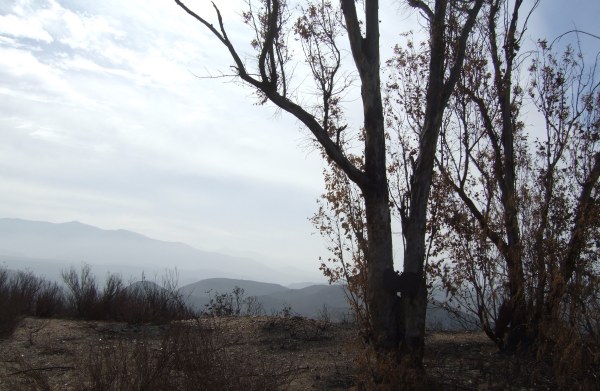
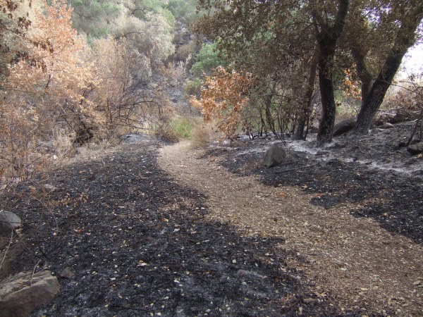
I put my mountain bike in my car and took off for the trailhead on the northernmost part of the huge open space preserve. I pedaled past "Canyon View" with the intention of replacing that container on my way back. I took a side trip to a viewpoint to take some pictures of the scorched hills.
A little twister was blowing across the blackened earth.
An unscorched rock, with an interesting notch in it framed the blackness behind it.
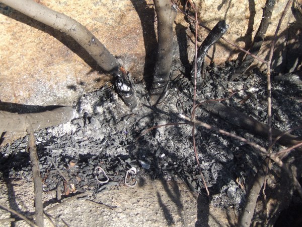
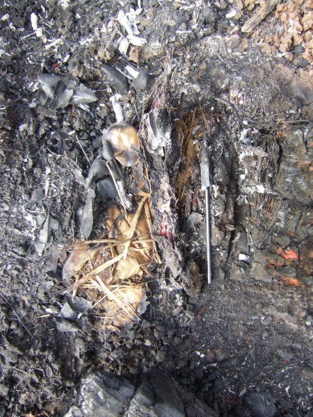
The burned smell permeated the air as I made me way down to my "Can-yon Oak" cache, which was a pill bottle cammoed by a rusty can — another one of my "patented" Miragee "can" cammo caches. The rusty can was still in place behind the boulder where I hid it, but inside, the pill bottle was a melted puddle of plastic.
I scraped the remanants of the cache out of the "cammo" and replaced it with a waterproof match container. I took several pictures at the location, hoping to get some of the same angles I took pictures from before, for a comparison.
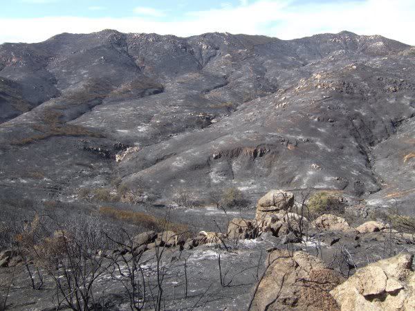
Down the trail a bit further, I took a picture of Lyons Peak. Although not taken from the same location, the comparison of what it looked like before the fire, and afterwards is easy to see. The first picture was taken earlier this year.


From there I pedaled down the trail towards my "Listen to the Silence; Enjoy the View" cache. At a distance, things didn't look good. The area was scorched and an interesting tree nearby was burned and down on the ground . . .
However, when I got to the rockpile and moved the rocks on top of the ammo can, it looked good. Then, I opened the top and was somewhat amazed everything inside the container was fine—none of the plastic items melted. That was sure good to see. I dropped off a Geocoin I picked up at last night's Event. Maybe that will help lure some people out to the area to see what the fire did.
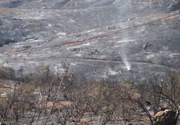
Not far from that location I took a picture of the valley below.
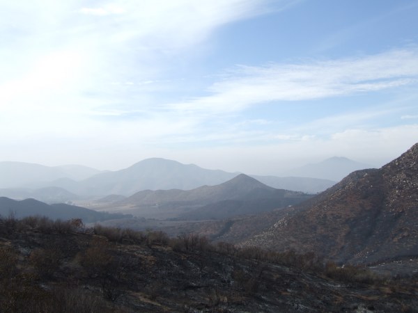
Although not taken from exactly the same place, or at the same time of day, the contrast can be seen, particularly in the foreground.

From there I made my way down to "Lonely Trees with a View." The small tin was visible when I got to the location, and the lid was not closed completely. I don't know if a fire fighter opened it to see what was inside and set it back down, or if a cacher left it that way. Inside, there was nothing but blackened ash, although two of my "glass baubles" and a marble in the container survived in a blackened state . . . When I emptied the container, some small gusts of wind quickly scattered what had been the pages of the log book.
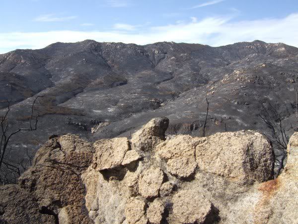
I took some pictures from that vantage point, trying to determine which caches far below me were gone for sure, and which ones might have survived. At that point I did not intend to go down, down, down to the lower level of the large Hollenbeck preserve. One of the pictures was of the little knoll where both a Terracache and GC reside.
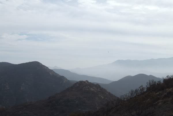
I took another picture looking towards the south, trying to capture both the view, and the beautiful clouds that accented the sky today.
I back-tracked to the location of one of "lostguy"'s caches, one of his "Couch" series. It took me quite a while to find the remnants of the container. This was all I saw . . .
I scratched through the ash with a stick I found nearby to see if anything salvageable could be found. The container had congealed into a lump. Then, as I stirred the ash, I found what looked like a Geocoin. It was blackened and un-recognizable, but had the correct size and weight.
Before walking back to my bicycle, which was parked near the road, I took more pictures of the trees near the cache location.
I walked back to my bicycle parked near the road. It was early in the day, so I decided to descend to the lower trail and check on the bradybunchboys "Hollenbeck Holiday Hide" and 3cd's "Hollenbeck" Terracache. Both were in perfect condition. From there, I pedaled down, down, down to the trail that makes a hard right turn to head north towards my "Elevation 999" and "Jamul Creek View" cache.
The first cache is an ammo can and it was in perfect condition. The fire just missed the immediate area, although a laurel bush on one side of the boulder is scorched. I dropped another Geocoin in that cache as an additional lure for cachers. I also updated the coordinates for the cache since my GPSr said GZ was 18' away. From there I walked and pedaled and walked up the steep grade to the site of "Jamul Creek View."
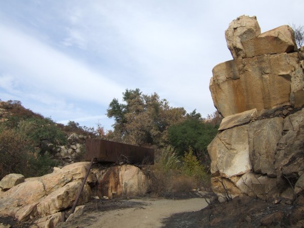
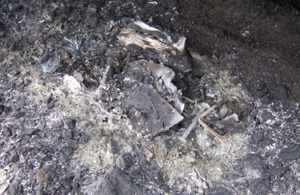
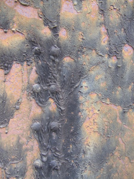
An interesting rusty container sits atop some boulders there and, to get cachers to further investigate and more closely inspect this odd artifact, I hid a plastic, magnetic key holder next to a supporting beam on the back side of the container. This is what I saw when I peered under to find my cache.
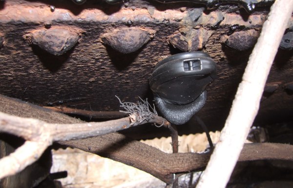
In my pack, I had a painted Altoids tin with magnets glued to the bottom of it, so I put a few trinkets and a new log in the container. Then I took some pictures of the weird melting patterns in the black tar that previously-covered the metal container.
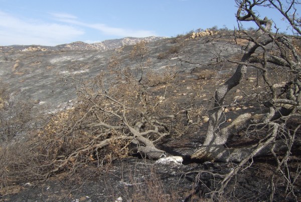
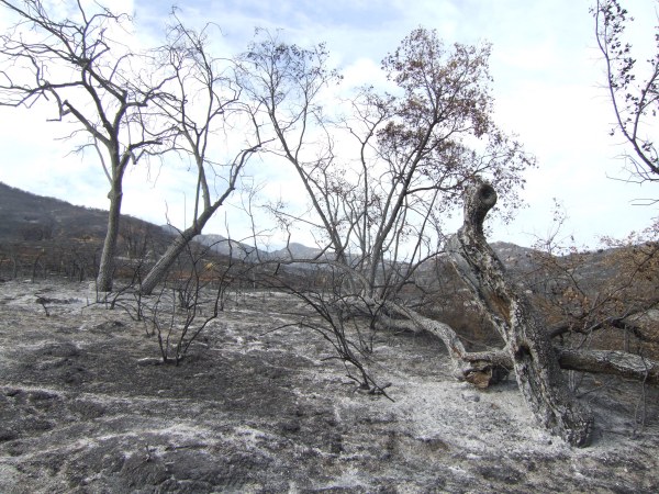
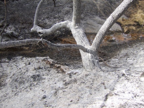
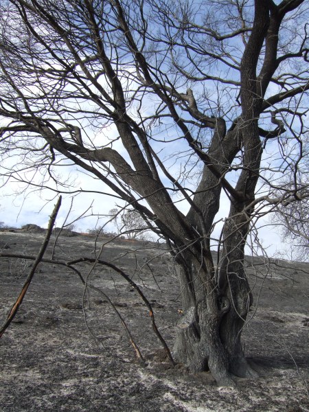
After that, I made my way up the very badly burned canyon. Even the leaves on the ground were scorched.
I had to get off the bicycle several times to walk it around downed trees. The heat of the fire in this densely forested canyon must have been incredible as evidenced by the white ash.
Before I left the house, I put the coordinates for the caches I have found in the canyon, and the caches I own into my GPSr. If it had not beeped as I got near this location, I would not have recognized it as the place where Chuy!'s "No Boundaries" was hidden.
The only thing in the plastic cigar tube that survived was the pencil lead.
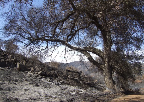
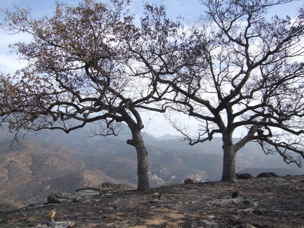
Dense shade from a canopy of oak trees covered this section of the trail. Poison oak was prevalent around this oak tree, and in the background, the hill was dense chapparal.
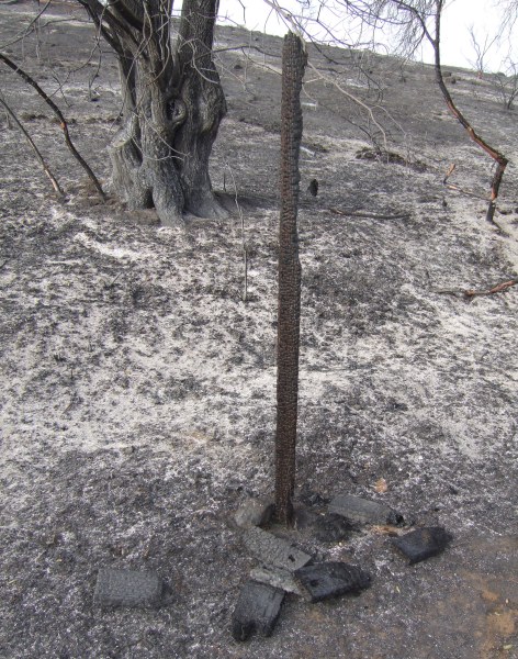
A bit further up the trail was another tree that showed the evidence of extreme heat . . .
The trail is very steep as it leaves the bottom of the canyon so I had to walk the bike most of the way up the trail towards the olive grove and the intersection of the trail I started down a few hours earlier. In my pack, I had a container FlagMan had given me the night before at the Event, and I was tempted to place a new cache. I saw some places where I could have hidden it, but the area is so devastated, and the ground so thorougly covered by ash, I did not want to place a container where a Geotrail would get started across the ash. Perhaps on a future trip, I'll find a hiding place right next to the trail.
At the top, I cleaned up the "Canyon View" location by getting rid of the burned branches. That opened up an area in the boulders where I could put out a new container, a small tin which will survive another fire, should there be one again years from now when the area recovers.
From my caching experience out in the desert, I learned that the best containers to use out there are either ammo cans or cookie or candy tins. Now that I have seen what fire does to plastic containers, I might replace all my plastic containers with tins, if they are in an area that is prone to the fires that are a natural factor in the chaparral environment.
By the time I returned to my car, I had covered almost six miles. The trip meter on my Garmin HCx recorded a much smaller distance, a problem reported with that particular GPSr model. Next time I get down to the library, where I connect to the Internet now, since I still do not have phone service, I'll have to update the firmware for my GPSr in hopes Garmin has fixed that problem.
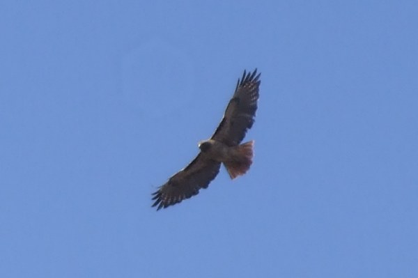
My adventure into Hollenbeck Canyon was amazing. The only wildlife I saw during the entire hike and ride were ravens and one Redtail hawk.
On future trips, it will be interesting to see what tracks develop across the ash. Will I see the tracks of a mountain lion as it makes it way from one unburned area to another?
A goal of mine should be to visit the area monthly and take pictures from the same locations, at the same time of the day, to see how everything changes. Next spring, especially if we get some rain this winter, the wildflowers will be incredible, as they were in the Horsethief Canyon area last year. I look forward to see the transition as it occurs, and as it has occurred in this chaparral/oak canyon habitat for thousands of years.
I put my mountain bike in my car and took off for the trailhead on the northernmost part of the huge open space preserve. I pedaled past "Canyon View" with the intention of replacing that container on my way back. I took a side trip to a viewpoint to take some pictures of the scorched hills.
A little twister was blowing across the blackened earth.
An unscorched rock, with an interesting notch in it framed the blackness behind it.
The burned smell permeated the air as I made me way down to my "Can-yon Oak" cache, which was a pill bottle cammoed by a rusty can — another one of my "patented" Miragee "can" cammo caches. The rusty can was still in place behind the boulder where I hid it, but inside, the pill bottle was a melted puddle of plastic.
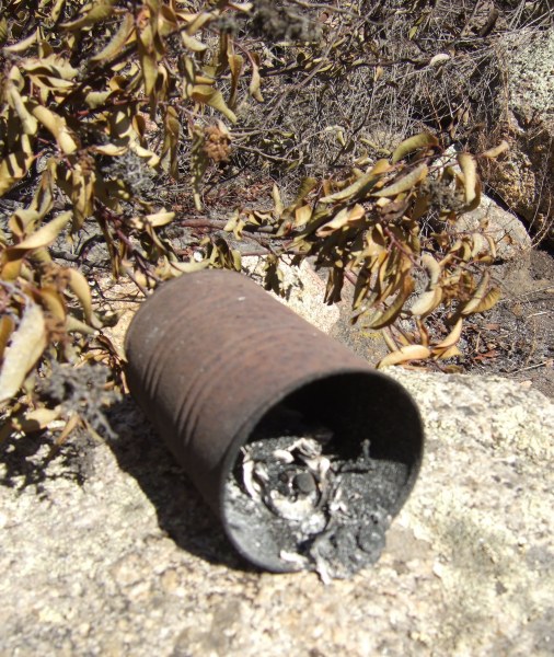
I scraped the remanants of the cache out of the "cammo" and replaced it with a waterproof match container. I took several pictures at the location, hoping to get some of the same angles I took pictures from before, for a comparison.
Down the trail a bit further, I took a picture of Lyons Peak. Although not taken from the same location, the comparison of what it looked like before the fire, and afterwards is easy to see. The first picture was taken earlier this year.
From there I pedaled down the trail towards my "Listen to the Silence; Enjoy the View" cache. At a distance, things didn't look good. The area was scorched and an interesting tree nearby was burned and down on the ground . . .
However, when I got to the rockpile and moved the rocks on top of the ammo can, it looked good. Then, I opened the top and was somewhat amazed everything inside the container was fine—none of the plastic items melted. That was sure good to see. I dropped off a Geocoin I picked up at last night's Event. Maybe that will help lure some people out to the area to see what the fire did.
Not far from that location I took a picture of the valley below.
Although not taken from exactly the same place, or at the same time of day, the contrast can be seen, particularly in the foreground.
From there I made my way down to "Lonely Trees with a View." The small tin was visible when I got to the location, and the lid was not closed completely. I don't know if a fire fighter opened it to see what was inside and set it back down, or if a cacher left it that way. Inside, there was nothing but blackened ash, although two of my "glass baubles" and a marble in the container survived in a blackened state . . . When I emptied the container, some small gusts of wind quickly scattered what had been the pages of the log book.
I took some pictures from that vantage point, trying to determine which caches far below me were gone for sure, and which ones might have survived. At that point I did not intend to go down, down, down to the lower level of the large Hollenbeck preserve. One of the pictures was of the little knoll where both a Terracache and GC reside.
I took another picture looking towards the south, trying to capture both the view, and the beautiful clouds that accented the sky today.
I back-tracked to the location of one of "lostguy"'s caches, one of his "Couch" series. It took me quite a while to find the remnants of the container. This was all I saw . . .
I scratched through the ash with a stick I found nearby to see if anything salvageable could be found. The container had congealed into a lump. Then, as I stirred the ash, I found what looked like a Geocoin. It was blackened and un-recognizable, but had the correct size and weight.
Before walking back to my bicycle, which was parked near the road, I took more pictures of the trees near the cache location.
I walked back to my bicycle parked near the road. It was early in the day, so I decided to descend to the lower trail and check on the bradybunchboys "Hollenbeck Holiday Hide" and 3cd's "Hollenbeck" Terracache. Both were in perfect condition. From there, I pedaled down, down, down to the trail that makes a hard right turn to head north towards my "Elevation 999" and "Jamul Creek View" cache.
The first cache is an ammo can and it was in perfect condition. The fire just missed the immediate area, although a laurel bush on one side of the boulder is scorched. I dropped another Geocoin in that cache as an additional lure for cachers. I also updated the coordinates for the cache since my GPSr said GZ was 18' away. From there I walked and pedaled and walked up the steep grade to the site of "Jamul Creek View."
An interesting rusty container sits atop some boulders there and, to get cachers to further investigate and more closely inspect this odd artifact, I hid a plastic, magnetic key holder next to a supporting beam on the back side of the container. This is what I saw when I peered under to find my cache.
In my pack, I had a painted Altoids tin with magnets glued to the bottom of it, so I put a few trinkets and a new log in the container. Then I took some pictures of the weird melting patterns in the black tar that previously-covered the metal container.
After that, I made my way up the very badly burned canyon. Even the leaves on the ground were scorched.
I had to get off the bicycle several times to walk it around downed trees. The heat of the fire in this densely forested canyon must have been incredible as evidenced by the white ash.
Before I left the house, I put the coordinates for the caches I have found in the canyon, and the caches I own into my GPSr. If it had not beeped as I got near this location, I would not have recognized it as the place where Chuy!'s "No Boundaries" was hidden.
The only thing in the plastic cigar tube that survived was the pencil lead.
Dense shade from a canopy of oak trees covered this section of the trail. Poison oak was prevalent around this oak tree, and in the background, the hill was dense chapparal.
A bit further up the trail was another tree that showed the evidence of extreme heat . . .
The trail is very steep as it leaves the bottom of the canyon so I had to walk the bike most of the way up the trail towards the olive grove and the intersection of the trail I started down a few hours earlier. In my pack, I had a container FlagMan had given me the night before at the Event, and I was tempted to place a new cache. I saw some places where I could have hidden it, but the area is so devastated, and the ground so thorougly covered by ash, I did not want to place a container where a Geotrail would get started across the ash. Perhaps on a future trip, I'll find a hiding place right next to the trail.
At the top, I cleaned up the "Canyon View" location by getting rid of the burned branches. That opened up an area in the boulders where I could put out a new container, a small tin which will survive another fire, should there be one again years from now when the area recovers.
From my caching experience out in the desert, I learned that the best containers to use out there are either ammo cans or cookie or candy tins. Now that I have seen what fire does to plastic containers, I might replace all my plastic containers with tins, if they are in an area that is prone to the fires that are a natural factor in the chaparral environment.
By the time I returned to my car, I had covered almost six miles. The trip meter on my Garmin HCx recorded a much smaller distance, a problem reported with that particular GPSr model. Next time I get down to the library, where I connect to the Internet now, since I still do not have phone service, I'll have to update the firmware for my GPSr in hopes Garmin has fixed that problem.
My adventure into Hollenbeck Canyon was amazing. The only wildlife I saw during the entire hike and ride were ravens and one Redtail hawk.
On future trips, it will be interesting to see what tracks develop across the ash. Will I see the tracks of a mountain lion as it makes it way from one unburned area to another?
A goal of mine should be to visit the area monthly and take pictures from the same locations, at the same time of the day, to see how everything changes. Next spring, especially if we get some rain this winter, the wildflowers will be incredible, as they were in the Horsethief Canyon area last year. I look forward to see the transition as it occurs, and as it has occurred in this chaparral/oak canyon habitat for thousands of years.
posted by Miragee at
8:31:00 PM
![]()
![]()

 10-Day Forecast


2 Comments:
Wow what devastation. Sorry about your caches.
By Anonymous, at 12:25 PM
Neat pics! Thanks for posting them. Fire is renewal; getting to see the early stages is rare.
You mentioned extreme heat. Actually if any part of the plant remains above ground, however charred, then it wasn't a terribly hot fire. These fires were very fast moving and therefore not particularly hot. Plenty hot enough to kill animals, including humans, of course. But a really hot fire would reduce absolutely everything to white ash even with more moisture, and it didn't.
My only surprise about the caches is how much you found -- another indication of fast moving fires. On the ammo boxes, was the rubber seal intact, or does it need replacing? I have several ammo boxes in fire-prone areas and have wondered whether the seal and contents would survive the next fire.
Edward
By paleolith, at 1:17 AM
Post a Comment
<< Home