A real "Treasure Trove" out in the wilderness
After a couple of days at home, I needed to get out and get some exercise. I noticed a new cache that went "live" when I was out in the desert two weeks ago. After reading the description, I realized the trailhead was at the now-familiar Horsethief Canyon staging area. I packed some snacks, filled my water bottles, and set out. After parking the car and starting the hike, I saw a trail marker I have never noticed before. The trail was narrow, but well marked and easy-to-follow, and it was less steep than the other one that goes down into the creek area about a quarter of a mile away.
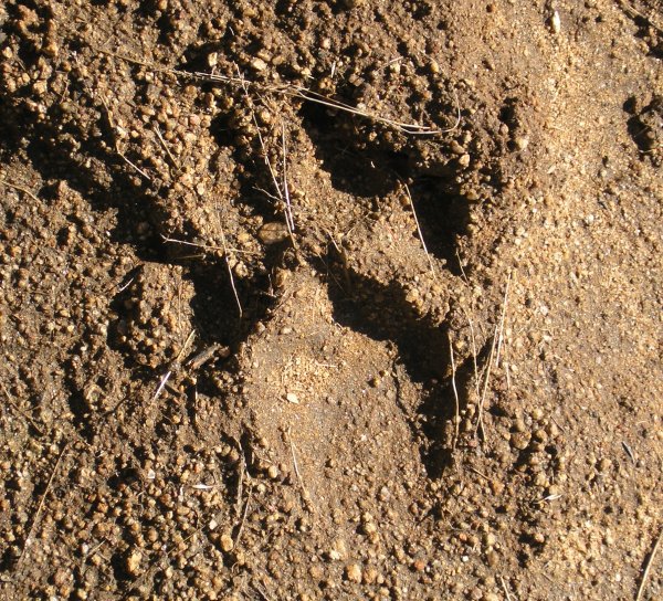
The air smelled fresh after the recent rains, and as I descended, I could hear the creek off in the distance. In the mud on the trail, I saw what looked like a mountain lion track.
It didn't take very long to get to the cache location. I circled it once to figure out how to get to the huge treasure chest.

The container was so heavy -- I cannot imagine how the cache owner got it and its contents down there.
I took several pictures and rummaged through everything, just amazed at what Latitude 32 had put in his "Treasure Trove." I left the California GeoCoin I picked up out of one of my caches last week -- its gold color went very well with all the other gold -- and I left a T.B. whose goal was "wants country caches."
After replacing the box and covering it up really well, I walked along the trail that follows the creek. I tried to get down to where I could get a good picture, but the sound of the water was more inviting than the locations were photogenic.
On my way back up the steep trail, I saw some hikers. I stopped and we talked for a while. They have a son who Geocaches, so they were familiar with what I was doing there, all by myself. Perhaps that is not the way to hike the Horsethief Canyon Wilderness Area expecially since I saw another "kitty" track along another part of the trail.

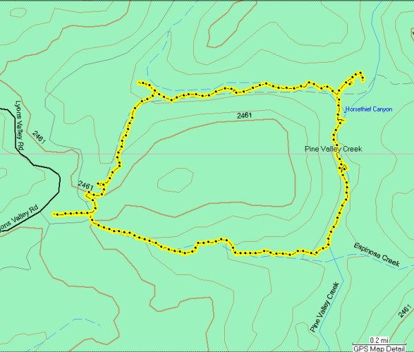
This is what my track looked like. I covered almost four miles and went down and back up about 750 feet of elevation.
It was a wonderful mid-day diversion, but I wasn't gone nearly long enough. There are two more hikes I need to take out this way, but each of them is more than two and a half miles. Four miles was enough for today.
The air smelled fresh after the recent rains, and as I descended, I could hear the creek off in the distance. In the mud on the trail, I saw what looked like a mountain lion track.
It didn't take very long to get to the cache location. I circled it once to figure out how to get to the huge treasure chest.
The container was so heavy -- I cannot imagine how the cache owner got it and its contents down there.
I took several pictures and rummaged through everything, just amazed at what Latitude 32 had put in his "Treasure Trove." I left the California GeoCoin I picked up out of one of my caches last week -- its gold color went very well with all the other gold -- and I left a T.B. whose goal was "wants country caches."
After replacing the box and covering it up really well, I walked along the trail that follows the creek. I tried to get down to where I could get a good picture, but the sound of the water was more inviting than the locations were photogenic.
On my way back up the steep trail, I saw some hikers. I stopped and we talked for a while. They have a son who Geocaches, so they were familiar with what I was doing there, all by myself. Perhaps that is not the way to hike the Horsethief Canyon Wilderness Area expecially since I saw another "kitty" track along another part of the trail.
This is what my track looked like. I covered almost four miles and went down and back up about 750 feet of elevation.
It was a wonderful mid-day diversion, but I wasn't gone nearly long enough. There are two more hikes I need to take out this way, but each of them is more than two and a half miles. Four miles was enough for today.
posted by Miragee at
4:29:00 PM
![]()
![]()

 10-Day Forecast


0 Comments:
Post a Comment
<< Home