A very early beginning to a late start on the highway
At 4:11 in the morning, I woke up. For more than an hour, I tried to fall back to sleep, but without success. Finally, I wriggled out of my sleeping bag and stuffed it in the stuff sack and packed everything away. A kind Wal-Mart employee let me in the store before it opened so I could use the restroom, wash my face, and brush my teeth.
I drove down Highway 50 to a restaurant that was open at 6:30 in the morning and treated myself to an omelet. On the four-day trip up to Lakewood, I didn't eat in any restaurants. Other than some bananas and grapes I bought along the way, I only ate food I brought with me, including nuts and dried fruit, and beans and rice I prepared ahead of time. For this homeward leg of the adventure, I did not have an opportunity to prepare any food. Sitting inside the country-chic-decorated restaurant was a treat for me.
By the time I finished my breakfast, the Sacred Ground coffee shop was open. They have a decent WiFi connection, and it is a lot more comfortable sitting inside that place than it is sitting in my car in the Days Inn parking lot. I downloaded my tracks and waypoints from the GPSr to the laptop, and loaded Geocaches for my route for the day, which was going to take me over Monarch Pass towards Montrose and somewhere beyond there.
At the coffee shop, I struck up a conversation with a man I saw there last spring. He uses the computer in the shop to check on foreign-currency investments. His kindness during our discussion was at odds with his reticent demeanor which made me hesitant to strike up a conversation originally, something that comes very naturally for me when I am traveling.
Finally, after finishing my coffee and packing up the laptop, I was ready to hit the road. But just then, a woman came in to ask me about my car, a 2003 5-speed Toyota Matrix, and the gas mileage it gets. As we talked, it turned out we had quite a bit in common, so we talked for more than an hour. By the time I finally started down the road, so many hours had elapsed I didn't try to reverse my DNF for "First Anniversary Cache" up on 'S' Mountain, nor make the hike to another cache on the east side of Salida.
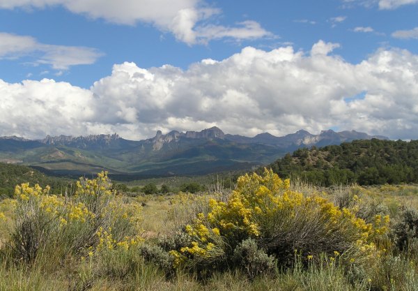
The views along my route over the pass and down the other side, were incredible. There were puffy clouds in the sky to accent the aspen trees which were starting to turn from green to yellow and orange. It was early enough in the process that none of the trees had lost their leaves yet. This picture was taken near "Fooses Creek Cache, one that was placed in 2002.


Outside of Montrose, I stopped for a little guard rail cache, "Woodgate Wetlands Cache. When I pulled into the turnout, I saw the cutest little deer look up at me from the meadow below. I reached for my camera, but the deer got spooked and took off . . . along with another larger deer that emerged from the brush. They bounded away like two very large jackrabbits.
In the small cache container, I was surprised to find a GJTB. Of course I had to take it, so, in "trade" for it, I left nscaler’s CA Poppy Geocoin.
From that cache, I started the incredibly-scenic drive towards Ridgway. I stopped to get the "Alkali Trail" cache I couldn’t find last spring. Since I now knew the coordinates were off, I was able to look around a bit and deduce where it might be hidden. I found it in the rocks, 28 feet away from GZ. I took new coordinates which I hope will be helpful for future seekers, especially those who make the hike from the trailhead, instead of those like me who take the 10-minute "window" of time to race down the trail from the Visitor Center to the cache site. The Visitor Center for the State Park has these astounding views.
It was great to remove the "Alkali Trail" cache from my "As-Yet-Unfound DNFs" Bookmark List and add it to my "Caches with a View" Bookmark List.
A bit further down the road, I walked along a nice hiking and biking trail to find a cache hidden near this old Dallas Townsite wooden waterpipe.
This was another artifact I saw along the trail.

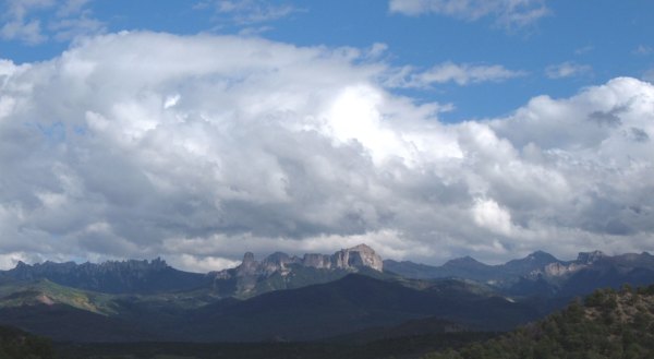
The pretty clouds from earlier in the day were coalescing into storm clouds, and when I got to the turnoff for Ridgway, there were a few raindrops slashing on the windshield. I dodged them as I walked over to get the Galloping Goose #1 Cache" at a little outdoor Railroad museum.
That area is so astonishingly scenic, I wish I had stopped driving and found a place to stay. However, the elevation there is more than 7,000 feet. With threatening skies overhead, I thought I should keep traveling south in hopes of finding clearer skies and warmer weather.
My next stop along the way was Ouray, Colorado, a town with a setting so astonishing it brought me to tears. I took lots of pictures of it, and of the scenery along the "Million Dollar Highway" to the mining town of Silverton.
That part of the drive today deserves its own Blog Entry.
I drove down Highway 50 to a restaurant that was open at 6:30 in the morning and treated myself to an omelet. On the four-day trip up to Lakewood, I didn't eat in any restaurants. Other than some bananas and grapes I bought along the way, I only ate food I brought with me, including nuts and dried fruit, and beans and rice I prepared ahead of time. For this homeward leg of the adventure, I did not have an opportunity to prepare any food. Sitting inside the country-chic-decorated restaurant was a treat for me.
By the time I finished my breakfast, the Sacred Ground coffee shop was open. They have a decent WiFi connection, and it is a lot more comfortable sitting inside that place than it is sitting in my car in the Days Inn parking lot. I downloaded my tracks and waypoints from the GPSr to the laptop, and loaded Geocaches for my route for the day, which was going to take me over Monarch Pass towards Montrose and somewhere beyond there.
At the coffee shop, I struck up a conversation with a man I saw there last spring. He uses the computer in the shop to check on foreign-currency investments. His kindness during our discussion was at odds with his reticent demeanor which made me hesitant to strike up a conversation originally, something that comes very naturally for me when I am traveling.
Finally, after finishing my coffee and packing up the laptop, I was ready to hit the road. But just then, a woman came in to ask me about my car, a 2003 5-speed Toyota Matrix, and the gas mileage it gets. As we talked, it turned out we had quite a bit in common, so we talked for more than an hour. By the time I finally started down the road, so many hours had elapsed I didn't try to reverse my DNF for "First Anniversary Cache" up on 'S' Mountain, nor make the hike to another cache on the east side of Salida.
The views along my route over the pass and down the other side, were incredible. There were puffy clouds in the sky to accent the aspen trees which were starting to turn from green to yellow and orange. It was early enough in the process that none of the trees had lost their leaves yet. This picture was taken near "Fooses Creek Cache, one that was placed in 2002.
Outside of Montrose, I stopped for a little guard rail cache, "Woodgate Wetlands Cache. When I pulled into the turnout, I saw the cutest little deer look up at me from the meadow below. I reached for my camera, but the deer got spooked and took off . . . along with another larger deer that emerged from the brush. They bounded away like two very large jackrabbits.
In the small cache container, I was surprised to find a GJTB. Of course I had to take it, so, in "trade" for it, I left nscaler’s CA Poppy Geocoin.
From that cache, I started the incredibly-scenic drive towards Ridgway. I stopped to get the "Alkali Trail" cache I couldn’t find last spring. Since I now knew the coordinates were off, I was able to look around a bit and deduce where it might be hidden. I found it in the rocks, 28 feet away from GZ. I took new coordinates which I hope will be helpful for future seekers, especially those who make the hike from the trailhead, instead of those like me who take the 10-minute "window" of time to race down the trail from the Visitor Center to the cache site. The Visitor Center for the State Park has these astounding views.
It was great to remove the "Alkali Trail" cache from my "As-Yet-Unfound DNFs" Bookmark List and add it to my "Caches with a View" Bookmark List.
A bit further down the road, I walked along a nice hiking and biking trail to find a cache hidden near this old Dallas Townsite wooden waterpipe.

This was another artifact I saw along the trail.
The pretty clouds from earlier in the day were coalescing into storm clouds, and when I got to the turnoff for Ridgway, there were a few raindrops slashing on the windshield. I dodged them as I walked over to get the Galloping Goose #1 Cache" at a little outdoor Railroad museum.
That area is so astonishingly scenic, I wish I had stopped driving and found a place to stay. However, the elevation there is more than 7,000 feet. With threatening skies overhead, I thought I should keep traveling south in hopes of finding clearer skies and warmer weather.
My next stop along the way was Ouray, Colorado, a town with a setting so astonishing it brought me to tears. I took lots of pictures of it, and of the scenery along the "Million Dollar Highway" to the mining town of Silverton.
That part of the drive today deserves its own Blog Entry.
posted by Miragee at
11:30:00 AM
![]()
![]()

 10-Day Forecast


0 Comments:
Post a Comment
<< Home