A reconnaissance trip into Horsethief Canyon
When fisnjack and I arrived at the staging area for Horsethief Canyon, there were several Forest Service and fire-fighting personnel there. I wanted to just put on my pack and start walking, but we ended up talking to some Forest Service people.
One firefighter was from Idaho and was also a Geocacher. But then, two Forest Service employees came over where we were talking and when fisnjack told them we were going to check on some caches, they said, "Geocaches aren't allowed in the National Forests." Grrrrrr! Timber companies can cut down the trees and mining companies can dig holes and leave behind toxic tailings piles and off-road vehicles and ATVs can create noise and air pollution in the National Forests, and these people are telling us we can't put out a few containers to hunt using our GPSr devices.
That negative conversation was not what I wanted to have before beginning our reconnaissance mission. It made me angry. Can you imagine how many thousands of caches would have to be removed from Forest Service land if what those two people told us was true, and was enforced?
Finally, even though they said the area was closed, we asked permission to walk down the road "to take pictures." They said "Okay." We walked down the road for quite a while, trying to scope out where Night Hunter's "That Man Stole My Horse" cache was. Fisnjack thought it was in the unburned area up the north fork of the canyon.
As we got closer to a direct view up the canyon, some other Forest Service personnel drove by. They also told us not to go into the canyon. After they drove on, we continued walking. Down the road, we got to an unburned area and fisnjack and I found a trail that descended into the canyon. We took it.
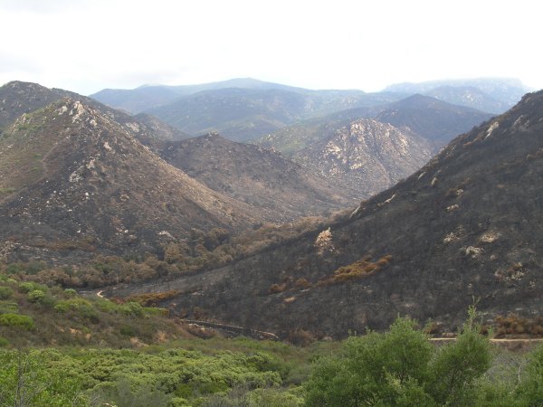
We walked through the unburned area in the canyon, hoping the Forest Service personnel had not seen us from their vantage point high on the road above us. As we continued on the trail, we really wanted to see the cache in the unburned area, but didn't. Fewer than 100 feet into the burn, we found the remains of the cache.
It is hard to imagine the huge hollow log the cache was hidden in disintegrated into nothing . . .
After packing up the container and its scorched contents, we debated a little about whether we should continue the .8 distance to "Latitude 32's cache." We decided to risk it and as we continued down the trail, we tried to hide when we heard helicopters fly overhead. Hiding wasn't very easy since most of the cover is gone now . . .
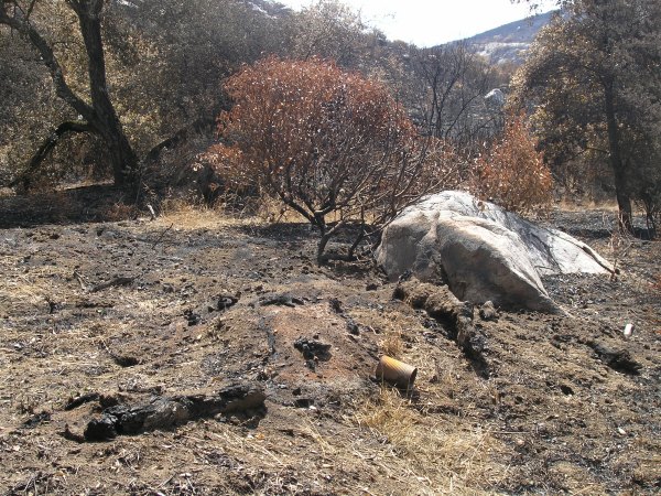
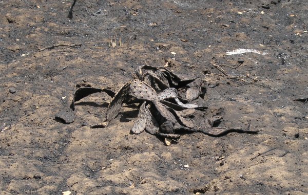
The destruction in parts of the canyon was total. Most of the oak trees will recover quickly. It will take longer for the other vegetation. This is what was left of a prickly pear cactus.
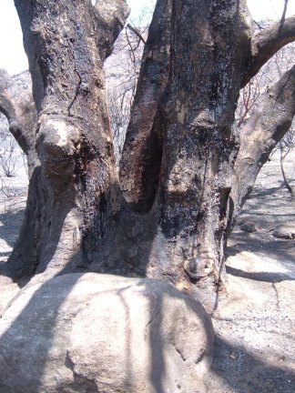
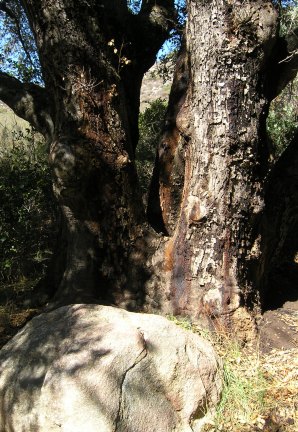
When we got to this tree, I remembered it. I had taken a picture of it last spring when I was in the canyon.
There was another cache in the canyon, and I thought fisnjack had the coordinates for it. Since we left in such a hurry, I didn't load the cache coordinates in my GPSr. I remembered basically what the cache location was like before, so we looked all along the trail as we walked through the completely scorched area. We did not see the ammo can. With all the fire fighters in the area putting out hot spots and flagging dangerous hanging branches after the fire raged through, they probably saw the ammo can near the trail and grabbed it.
After walking for half an hour, only stopping to take pictures and occasionally wait under a tree as another helicopter flew over, we made it to GZ for "Latitude 32's Treasure Trove" cache. We searched around the scorched rocks and poked the ash-covered ground with our walking sticks for a long time. I was ready to leave when fisnjack hit something with his trekking pole.
This is what was left of "Latitude 32's Treasure Trove" cache.
When I found it last March, it looked like this.

After recovering all the coins and metal parts of the treasure box, we loaded up our packs and headed back the way we came.
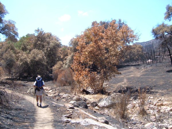
I took this picture of fisnjack walking along the creek that used to be completely blocked from view by a dense growth of shrubs.
When we finally got back to the staging area, there was no one there to arrest us. Wheeuuw!
I am sure they will officially close the area for "habitat restoration," but since it is so interesting to see what fire does to a habitat like this, which has adapted to fire as a natural part of succession, I wish they wouldn't.
Before it is closed, I hope others get a chance to see, and photograph, the canyon.
One firefighter was from Idaho and was also a Geocacher. But then, two Forest Service employees came over where we were talking and when fisnjack told them we were going to check on some caches, they said, "Geocaches aren't allowed in the National Forests." Grrrrrr! Timber companies can cut down the trees and mining companies can dig holes and leave behind toxic tailings piles and off-road vehicles and ATVs can create noise and air pollution in the National Forests, and these people are telling us we can't put out a few containers to hunt using our GPSr devices.
That negative conversation was not what I wanted to have before beginning our reconnaissance mission. It made me angry. Can you imagine how many thousands of caches would have to be removed from Forest Service land if what those two people told us was true, and was enforced?
Finally, even though they said the area was closed, we asked permission to walk down the road "to take pictures." They said "Okay." We walked down the road for quite a while, trying to scope out where Night Hunter's "That Man Stole My Horse" cache was. Fisnjack thought it was in the unburned area up the north fork of the canyon.
As we got closer to a direct view up the canyon, some other Forest Service personnel drove by. They also told us not to go into the canyon. After they drove on, we continued walking. Down the road, we got to an unburned area and fisnjack and I found a trail that descended into the canyon. We took it.
We walked through the unburned area in the canyon, hoping the Forest Service personnel had not seen us from their vantage point high on the road above us. As we continued on the trail, we really wanted to see the cache in the unburned area, but didn't. Fewer than 100 feet into the burn, we found the remains of the cache.
It is hard to imagine the huge hollow log the cache was hidden in disintegrated into nothing . . .
After packing up the container and its scorched contents, we debated a little about whether we should continue the .8 distance to "Latitude 32's cache." We decided to risk it and as we continued down the trail, we tried to hide when we heard helicopters fly overhead. Hiding wasn't very easy since most of the cover is gone now . . .
The destruction in parts of the canyon was total. Most of the oak trees will recover quickly. It will take longer for the other vegetation. This is what was left of a prickly pear cactus.
When we got to this tree, I remembered it. I had taken a picture of it last spring when I was in the canyon.
There was another cache in the canyon, and I thought fisnjack had the coordinates for it. Since we left in such a hurry, I didn't load the cache coordinates in my GPSr. I remembered basically what the cache location was like before, so we looked all along the trail as we walked through the completely scorched area. We did not see the ammo can. With all the fire fighters in the area putting out hot spots and flagging dangerous hanging branches after the fire raged through, they probably saw the ammo can near the trail and grabbed it.
After walking for half an hour, only stopping to take pictures and occasionally wait under a tree as another helicopter flew over, we made it to GZ for "Latitude 32's Treasure Trove" cache. We searched around the scorched rocks and poked the ash-covered ground with our walking sticks for a long time. I was ready to leave when fisnjack hit something with his trekking pole.
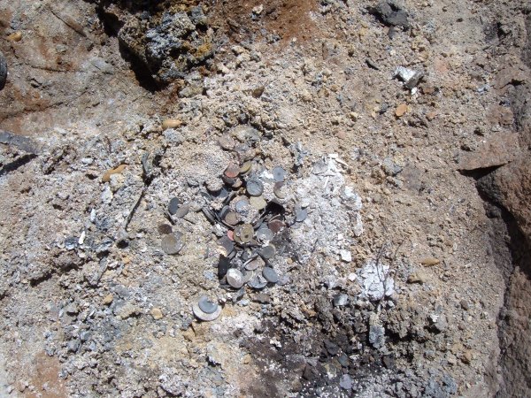
This is what was left of "Latitude 32's Treasure Trove" cache.
When I found it last March, it looked like this.
After recovering all the coins and metal parts of the treasure box, we loaded up our packs and headed back the way we came.
I took this picture of fisnjack walking along the creek that used to be completely blocked from view by a dense growth of shrubs.
When we finally got back to the staging area, there was no one there to arrest us. Wheeuuw!
I am sure they will officially close the area for "habitat restoration," but since it is so interesting to see what fire does to a habitat like this, which has adapted to fire as a natural part of succession, I wish they wouldn't.
Before it is closed, I hope others get a chance to see, and photograph, the canyon.
posted by Miragee at
6:41:00 PM
![]()
![]()

 10-Day Forecast


0 Comments:
Post a Comment
<< Home