A great day of caching on Otay Mountain with fisnjack
For several weeks now, fisnjack has been after me to join him on a trip up Otay Truck Trail to get the new caches placed up there by Pathfinder and Snoopy. When I wasn't feeling well a couple of weeks ago, I wouldn't have made good company. However, now I was feeling better, and had even prepared some new caches to place, if/when I found a good location.
On an overcast morning, with the marine layer hanging low, I met fisnjack at the trailhead for Hollenback Canyon and we headed east on Highway 94 to Marron Valley Road. A few miles in on that graded road, we found the turnoff to the south that heads up the steep, narrow Otay Truck Trail.
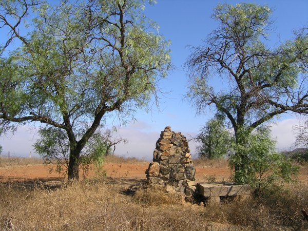
The first caches we looked for were two more of the caches in Night Hunter's "Stone Ruination" series.
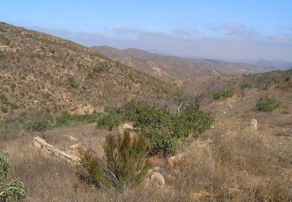
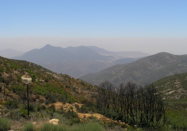
In the second picture, you can see the marine layer breaking up below, but it never cleared enough to give us the astounding views the Otay Mountain road offers.
After finding a few caches, one of which was an ammo can in which I put a Geocoin I hope will be safe from the Coin and Jeep thief, we stopped at a pullout where there wasn't a cache yet. There is now. It was near one of the roadside mirrors that help drivers see oncoming traffic. These roadside mirrors also provide an opportunity to be creative with the incredible views offered on really clear days.
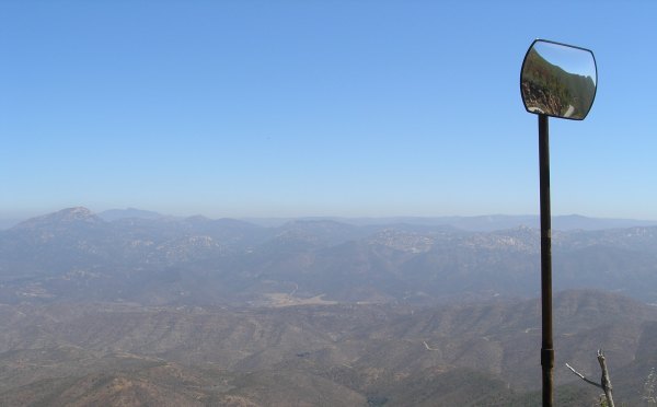
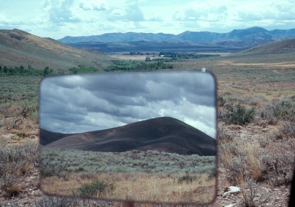
Years ago, when I lived in Idaho, I was visiting a friend on his ranch. I took a picture of the view looking ahead, with the stormy view behind me reflected in the rear view mirror. These roadside mirrors reminded me of that picture.
We drove up the road and found another interesting spot for a cache and while we were there, Sledhead and a friend from Ogden, Utah drove up. We talked for a long time before the two of them, and fisnjack, decided to go down the road to "beta test" my new cache. When they got back, I gave them the coordinates for the new cache at this location, and they found it "right on the numbers."
There is another one of those mirrors in that picture. Can you see it? If only it had been clearer. The view from there is fantastic.
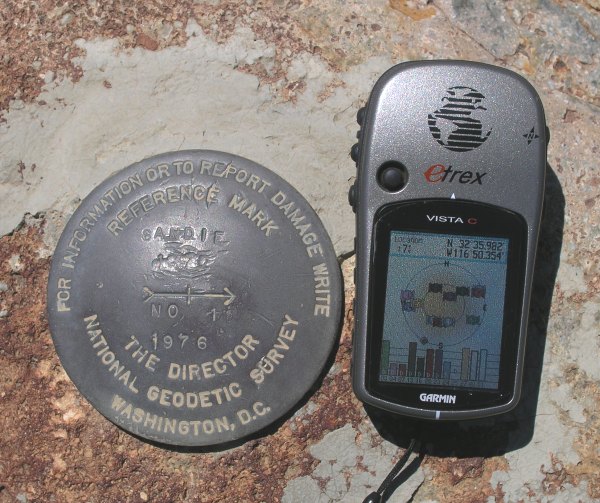
Near my new cache is a benchmark I found on top of one of the boulders. I didn't expect it to be an official Benchmark I could log on GC.com, but it was.
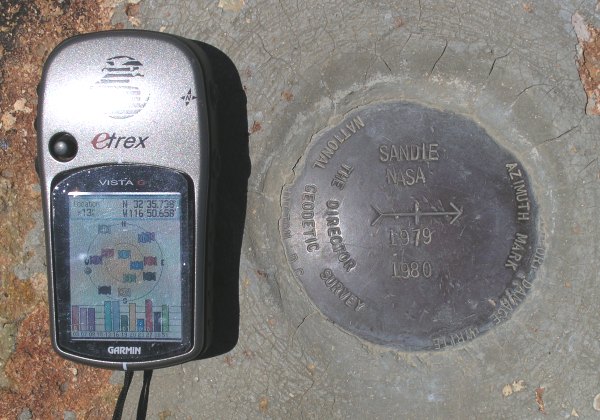
That one goes with this one we found on the top of Otay Mountain near a Terracache.
If we had more time, we might have tried to find the actual benchmark these two referred to.
On the peak, we found the "O-Tay Mountain" Terracache. This was a cache fisnjack drove all the way up to and tried to find right after it was posted. He expected the cache to be an ammo can, so he spent more than 30 minutes looking for a hiding place large enough for a cache that size. It turned out Passing Wind had placed an Altoids tin up there. Just before we got to GZ, the batteries in my GPSr died. I thought the cache would be higher on the hill, but fisnjack followed the arrow on his GPSr to GZ, an area he was very familiar with. He was familiar with the hint that had been placed on the cache page now and found the cache right away. That was his second Terracaching FTF. His first was for my Carveacre Wind Caves Terracache.
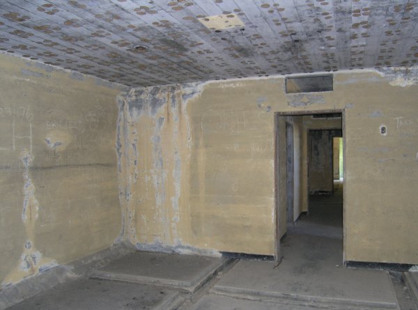
Below the peak was the infamous "WWII Bunkers" cache which recently had several DNFs. On our way to the hiding place, fisnjack and I walked through the building. The acrid smell of gear oil and gunpowder was still present.
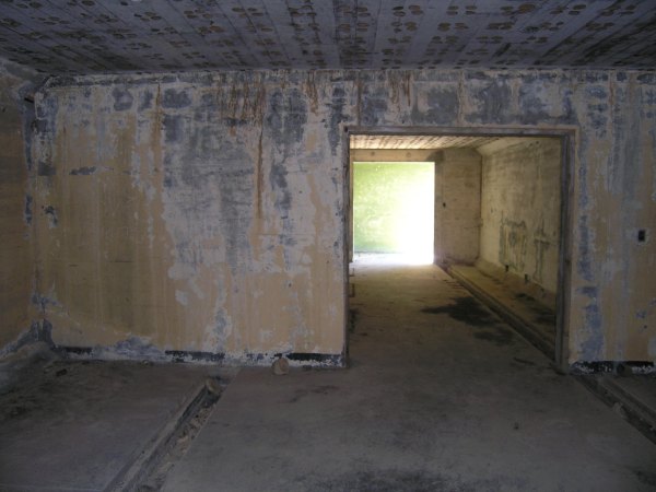
Soundproofing that was attached to the ceiling is gone now, but you can see the spots where it was glued to the concrete. The purpose of the deep, formed trenches in the floor were a mystery to me.
As we continued down the road, we came to Otay 3.2. Since there is a "companion" cache at Otay 3.5, I thought this would be a good place for the third of the four caches I brought with me.
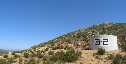
I used another one of my rusty cans as cammo for the waterproof match container. I would have taken pictures of the incredible views from that location, but it was just too hazy and I knew the pictures wouldn't come out very well . . . and I didn't want to waste that expensive digital film . . .
We continued down the road until there was a sort of "pennisula" with a viewpoint of eastern Tijuana. I only had one cache container left with me . . . a large bison tube given to me by "lostguy". I didn't want the cache to be difficult to find in that previously-burned area where the bushes are small and just starting to recover. I finally tied it from a burnt stick which ends in a small bush. Nearby, I piled up a few rocks to create a Geopile. My hint on the cache page is: "Not hidden in the nearby Geopile."
By the time we got off the mountain, we covered more than 20 miles on the Truck Trail, and a couple of its side roads, at an average speed of only three miles per hour. I found 11 caches and placed four. Since he had already been on the mountain before, I think fisnjack found fewer than ten caches, including the four he Beta Tested for me.
Once again I had a great day. Since that road is in good condition, as soon as it is really, really clear, I would like to take a drive up there myself to get some more pictures of the astounding views.
On an overcast morning, with the marine layer hanging low, I met fisnjack at the trailhead for Hollenback Canyon and we headed east on Highway 94 to Marron Valley Road. A few miles in on that graded road, we found the turnoff to the south that heads up the steep, narrow Otay Truck Trail.
The first caches we looked for were two more of the caches in Night Hunter's "Stone Ruination" series.
In the second picture, you can see the marine layer breaking up below, but it never cleared enough to give us the astounding views the Otay Mountain road offers.
After finding a few caches, one of which was an ammo can in which I put a Geocoin I hope will be safe from the Coin and Jeep thief, we stopped at a pullout where there wasn't a cache yet. There is now. It was near one of the roadside mirrors that help drivers see oncoming traffic. These roadside mirrors also provide an opportunity to be creative with the incredible views offered on really clear days.
Years ago, when I lived in Idaho, I was visiting a friend on his ranch. I took a picture of the view looking ahead, with the stormy view behind me reflected in the rear view mirror. These roadside mirrors reminded me of that picture.
We drove up the road and found another interesting spot for a cache and while we were there, Sledhead and a friend from Ogden, Utah drove up. We talked for a long time before the two of them, and fisnjack, decided to go down the road to "beta test" my new cache. When they got back, I gave them the coordinates for the new cache at this location, and they found it "right on the numbers."
There is another one of those mirrors in that picture. Can you see it? If only it had been clearer. The view from there is fantastic.
Near my new cache is a benchmark I found on top of one of the boulders. I didn't expect it to be an official Benchmark I could log on GC.com, but it was.
That one goes with this one we found on the top of Otay Mountain near a Terracache.
If we had more time, we might have tried to find the actual benchmark these two referred to.
On the peak, we found the "O-Tay Mountain" Terracache. This was a cache fisnjack drove all the way up to and tried to find right after it was posted. He expected the cache to be an ammo can, so he spent more than 30 minutes looking for a hiding place large enough for a cache that size. It turned out Passing Wind had placed an Altoids tin up there. Just before we got to GZ, the batteries in my GPSr died. I thought the cache would be higher on the hill, but fisnjack followed the arrow on his GPSr to GZ, an area he was very familiar with. He was familiar with the hint that had been placed on the cache page now and found the cache right away. That was his second Terracaching FTF. His first was for my Carveacre Wind Caves Terracache.
Below the peak was the infamous "WWII Bunkers" cache which recently had several DNFs. On our way to the hiding place, fisnjack and I walked through the building. The acrid smell of gear oil and gunpowder was still present.
Soundproofing that was attached to the ceiling is gone now, but you can see the spots where it was glued to the concrete. The purpose of the deep, formed trenches in the floor were a mystery to me.
As we continued down the road, we came to Otay 3.2. Since there is a "companion" cache at Otay 3.5, I thought this would be a good place for the third of the four caches I brought with me.
I used another one of my rusty cans as cammo for the waterproof match container. I would have taken pictures of the incredible views from that location, but it was just too hazy and I knew the pictures wouldn't come out very well . . . and I didn't want to waste that expensive digital film . . .
We continued down the road until there was a sort of "pennisula" with a viewpoint of eastern Tijuana. I only had one cache container left with me . . . a large bison tube given to me by "lostguy". I didn't want the cache to be difficult to find in that previously-burned area where the bushes are small and just starting to recover. I finally tied it from a burnt stick which ends in a small bush. Nearby, I piled up a few rocks to create a Geopile. My hint on the cache page is: "Not hidden in the nearby Geopile."
By the time we got off the mountain, we covered more than 20 miles on the Truck Trail, and a couple of its side roads, at an average speed of only three miles per hour. I found 11 caches and placed four. Since he had already been on the mountain before, I think fisnjack found fewer than ten caches, including the four he Beta Tested for me.
Once again I had a great day. Since that road is in good condition, as soon as it is really, really clear, I would like to take a drive up there myself to get some more pictures of the astounding views.
posted by Miragee at
2:07:00 PM
![]()
![]()

 10-Day Forecast


0 Comments:
Post a Comment
<< Home