I got my first Terracache FTF!
Across the valley from Gaskill Peak, there is an amazing rocky peak. From the trail up to Gaskill Peak, and from the Carveacre Wind Cave location, I have viewed that peak and wondered how to get to it. Of course I wondered why there weren't any caches on it.

Well, finally, after a lot of research, Gecko Dad figured out how to access the peak legally through public access trails. He placed two caches on the peak and one on the trail below it near where a "trail" is marked by green ribbons.
Yesterday, the weather was cooler than it has been, so I drove the back road from my house to Alpine to find the trailhead.
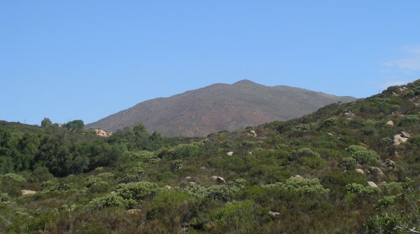
I asked my GPSr to route me to the trailhead, but it got confused because it thought Spanish Bit Rd. was something I could turn onto . . . and I couldn't. So, I reached a dead end, but the California Riding and Hiking trail started there, and I could see the peak, so I took off. The trail went down into a gully and then up a steep hill. I took a picture of Viejas Mountain from a vantage point along the trail.
Soon after that, I got to a high point on the trail where I could see Bell Bluff . . . and I could also see the huge canyon between me and the trail on the other side.
Whoops . . . I was on the wrong section of the California Riding and Hiking trail.
So, I walked back to my car and drove to the intersection named in the cache description. I also entered the coordinates for the trailhead. Finding it was almost like finding a cache. It was well hidden next to a large gate that makes that open area look closed.
The beginning of the trail heads south down into a wetlands that is green and cool. Then the trail goes up into the chaparral area that is recovering from the October 2003 fires. For more than two miles along the trail, there is no shade, so I don't know how Gecko Dad did this hike and placed the caches when it was over 110°.
Before the trail splits off, with one section heading towards Loveland Reservoir, and the other section heading towards Bell Bluff, there is a great view of the peak.
I thought I missed the fork, so I backtracked to investigate an eroded trail that went to the north. Once again, I had made a wrong turn, so I backtracked and continued on to the fork. I took the coordinates there in case Gecko Dad wants them for his cache description.
As I walked, I watched the distance to the cache diminish slowly. I seriously thought I would just get to the cache at the bottom and turn around. The mountain looked so daunting, and the day was getting much warmer than it had been two hours earlier.
Finally, I made it to the "Green Ribbons to Bell Bluff" cache.
Gecko Dad's coordinates turned out to be perfect, but until I used the detailed hint to find the well-hidden green waterproof match container, I didn't know that. After such a long walk, it would not have been very fun to spend a lot of time trying to find the container.
From that cache, the distance to the top, as the crow flies, wasn't very far, and the faint trail looked doable.
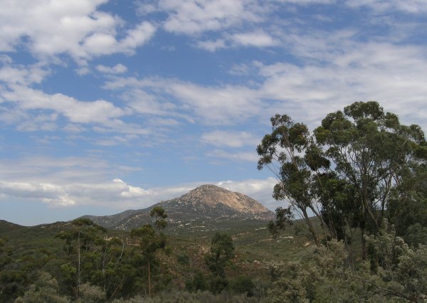
I followed the green ribbons, and the older orange and pink ribbons, up, up, and up. The vistas revealed as I got higher, like this one of Viejas Mountain, were fantastic.
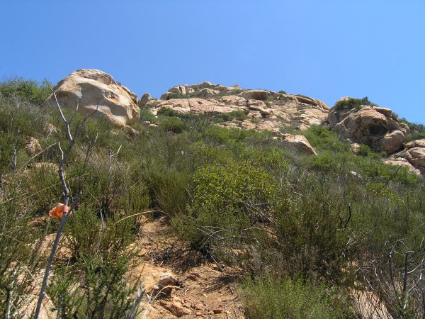
After an hour of climbing, I was finally at the top. The closest cache was the Terracache, "Ringing the Bell." I wandered up and around the boulders near GZ, but the batteries in my GPSr were low and the signal was erratic. After I changed the batteries, I found GZ, but still couldn't see the cache. Using my walking stick, I poked some hidey holes and finally heard that wonderful sound of stick on cache.
The logbook was blank. There was a paper for the FTF code, and another confirmation code in the logbook. I signed the log and traded for the beautiful silver gecko charm.
The Geocache, "Bell Bluff - Alpine's Mini-El Capitan" was less than 200 feet away, so I made my way over the rocks and boulders to it. Once again, Gecko Dad's coordinates were perfect. I wonder if he also has a Vista C? Although the hiding spot is not obvious, I saw it right away. Even so, he included a detailed hint in his cache description. I sure appreciated that. No one wants to make a hike that long and hard and then have trouble finding the cache.
I signed the logbook and retrieved Bad Andy's coin out of the cache. BadAndy's coin has an interesting Latin inscription.
As near as I can tell, from an online Latin dictionary, that means: Trade up or Trade Even.
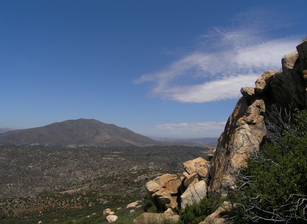
Now that I had found both caches, I had time to play. I took some more pictures. This one is toward Hauser Canyon and the Hauser Wilderness area that burned in the recent fire.
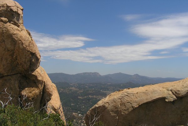
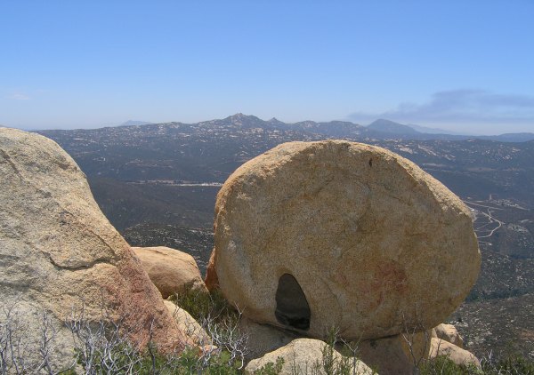
I found this rock with a hole in it that offered an interesting foreground to the view of Gaskill Peak, Lawson Peak, and smoke from a fire off behind Lyons Peak.
Then, I found the benchmarks on the peak, and signed the peak register.
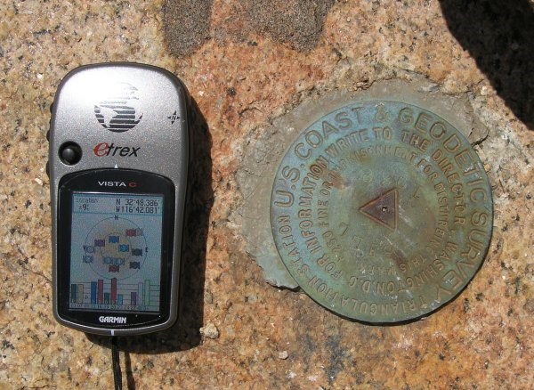
Later, when I logged that benchmark, it turned out I was the first Geocacher to log that one. Whoooo Hoo . . . another first for this adventure.
I really wanted to stay on the peak and play some more. I love huge boulders like those, and the ones on the north end of Iron Mountain where my "Boulders with a View," resides, and the enormous ones on Gower Mountain, where "Mega Boulders -- Micro Cache" is hidden. Another fun mountain with lots of huge boulders is Indian Head Peak.
Even though I wanted to wander around, explore, and take more pictures, the day was getting warmer, and I only had 24 ounces of water left for the return hike. To find the elusive Green Ribbon trail, I referred to the tracks on my GPSr and reluctantly started down from the peak.
On the way back, I took more pictures of the amazing scenery along the way.

On the return hike, I rationed the water and only finished off the last of it when I had my car in sight. At the car, I got the quart bottle of water out of my cooler and drank all of it.
It was a wonderful adventure. Coupled with the hike Sunday when I placed three caches, my love of Geocaching has returned. This is what the sport/game/activity/addiction is all about for me.
Well, finally, after a lot of research, Gecko Dad figured out how to access the peak legally through public access trails. He placed two caches on the peak and one on the trail below it near where a "trail" is marked by green ribbons.
Yesterday, the weather was cooler than it has been, so I drove the back road from my house to Alpine to find the trailhead.
I asked my GPSr to route me to the trailhead, but it got confused because it thought Spanish Bit Rd. was something I could turn onto . . . and I couldn't. So, I reached a dead end, but the California Riding and Hiking trail started there, and I could see the peak, so I took off. The trail went down into a gully and then up a steep hill. I took a picture of Viejas Mountain from a vantage point along the trail.
Soon after that, I got to a high point on the trail where I could see Bell Bluff . . . and I could also see the huge canyon between me and the trail on the other side.
Whoops . . . I was on the wrong section of the California Riding and Hiking trail.
So, I walked back to my car and drove to the intersection named in the cache description. I also entered the coordinates for the trailhead. Finding it was almost like finding a cache. It was well hidden next to a large gate that makes that open area look closed.
The beginning of the trail heads south down into a wetlands that is green and cool. Then the trail goes up into the chaparral area that is recovering from the October 2003 fires. For more than two miles along the trail, there is no shade, so I don't know how Gecko Dad did this hike and placed the caches when it was over 110°.
Before the trail splits off, with one section heading towards Loveland Reservoir, and the other section heading towards Bell Bluff, there is a great view of the peak.
I thought I missed the fork, so I backtracked to investigate an eroded trail that went to the north. Once again, I had made a wrong turn, so I backtracked and continued on to the fork. I took the coordinates there in case Gecko Dad wants them for his cache description.
As I walked, I watched the distance to the cache diminish slowly. I seriously thought I would just get to the cache at the bottom and turn around. The mountain looked so daunting, and the day was getting much warmer than it had been two hours earlier.
Finally, I made it to the "Green Ribbons to Bell Bluff" cache.
Gecko Dad's coordinates turned out to be perfect, but until I used the detailed hint to find the well-hidden green waterproof match container, I didn't know that. After such a long walk, it would not have been very fun to spend a lot of time trying to find the container.
From that cache, the distance to the top, as the crow flies, wasn't very far, and the faint trail looked doable.
I followed the green ribbons, and the older orange and pink ribbons, up, up, and up. The vistas revealed as I got higher, like this one of Viejas Mountain, were fantastic.
After an hour of climbing, I was finally at the top. The closest cache was the Terracache, "Ringing the Bell." I wandered up and around the boulders near GZ, but the batteries in my GPSr were low and the signal was erratic. After I changed the batteries, I found GZ, but still couldn't see the cache. Using my walking stick, I poked some hidey holes and finally heard that wonderful sound of stick on cache.
The logbook was blank. There was a paper for the FTF code, and another confirmation code in the logbook. I signed the log and traded for the beautiful silver gecko charm.
The Geocache, "Bell Bluff - Alpine's Mini-El Capitan" was less than 200 feet away, so I made my way over the rocks and boulders to it. Once again, Gecko Dad's coordinates were perfect. I wonder if he also has a Vista C? Although the hiding spot is not obvious, I saw it right away. Even so, he included a detailed hint in his cache description. I sure appreciated that. No one wants to make a hike that long and hard and then have trouble finding the cache.
I signed the logbook and retrieved Bad Andy's coin out of the cache. BadAndy's coin has an interesting Latin inscription.
mutuus sursum vel mutuus parkilis
As near as I can tell, from an online Latin dictionary, that means: Trade up or Trade Even.
Now that I had found both caches, I had time to play. I took some more pictures. This one is toward Hauser Canyon and the Hauser Wilderness area that burned in the recent fire.
I found this rock with a hole in it that offered an interesting foreground to the view of Gaskill Peak, Lawson Peak, and smoke from a fire off behind Lyons Peak.
Then, I found the benchmarks on the peak, and signed the peak register.
Later, when I logged that benchmark, it turned out I was the first Geocacher to log that one. Whoooo Hoo . . . another first for this adventure.
I really wanted to stay on the peak and play some more. I love huge boulders like those, and the ones on the north end of Iron Mountain where my "Boulders with a View," resides, and the enormous ones on Gower Mountain, where "Mega Boulders -- Micro Cache" is hidden. Another fun mountain with lots of huge boulders is Indian Head Peak.
Even though I wanted to wander around, explore, and take more pictures, the day was getting warmer, and I only had 24 ounces of water left for the return hike. To find the elusive Green Ribbon trail, I referred to the tracks on my GPSr and reluctantly started down from the peak.
On the way back, I took more pictures of the amazing scenery along the way.
On the return hike, I rationed the water and only finished off the last of it when I had my car in sight. At the car, I got the quart bottle of water out of my cooler and drank all of it.
It was a wonderful adventure. Coupled with the hike Sunday when I placed three caches, my love of Geocaching has returned. This is what the sport/game/activity/addiction is all about for me.
posted by Miragee at
9:05:00 AM
![]()
![]()

 10-Day Forecast


1 Comments:
thats awesome. ive made this climb before as i live nearby. i need to get into geocaching. glad you were able to make the climb and make it back down. i had to make it down this one in the dusk and i almost stumbled off a few significant cliffs. wonderful peak, with palo verde lake below
By Unknown, at 1:09 PM
Post a Comment
<< Home