It was going to be warm, so we headed toward the coast Tuesday
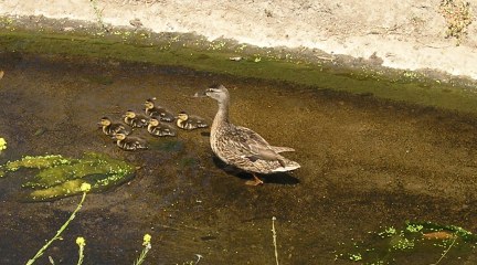
It was going to be warm out in the east County area, so I met up with Princess Toadstool and we headed off in the direction of Carl's "Always the Hard Way" cache that we couldn't find last week. We parked in the nearby residential area and walked the correct path this time, seeing a mother duck and her young'uns along the way.
I really thought the cache was going to be attached to a rock, or piece of concrete, and well-cammoed in that way, so I was surprised to find a container favored by Duscwe! hidden beneath something mentioned in the hint. The extra hint from Carl helped because our GPSrs had us looking a bit further to the south on our original hunt.
From there we headed toward Tecolote Canyon and Devhead's "Tecolote Challenge." This was going to be P.T.'s third visit to the canyon, so she is really getting to know those treacherous washouts and the other twists and turns in the trail. Devhead provided some updated coordinates, but under that heavy tree cover, I'm not sure how helpful they were. However, someone in the Forums had been asking about hiding caches "in the air," so that got me to look up, and that is where the cache was. You had to climb up the tree to get it down from the little rope cradle it was resting in.
I launched my new Travel Bug in this location. I picked up "Consistent Compass" at the Boy Scout cache off Regents road last week.
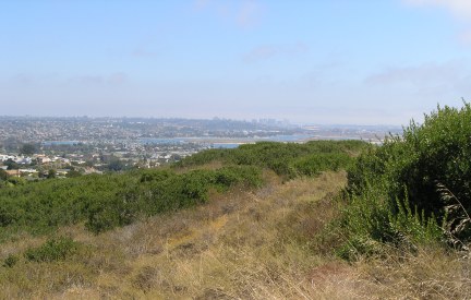
The rest of our day took us to some of the most scenic locations in the San Diego area in La Jolla and finally up on Mt. Soledad. We went to the "Thank You, San Diego" cache, and the "Vintage: Coast PB Jar," which is one of the oldest caches in the San Diego area.
The views from both caches were astounding, although the day was a bit hazy. This is a spot to keep in mind for one of those crystal-clear days after a rainstorm in the winter.
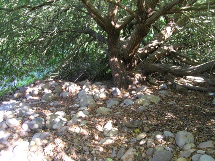
We made out way to the trailhead for The Spooky Tree and that was quite a walk. The trail follows a "creekbed" that must have been very treacherous this past winter. As it is, it can be treacherous in places because most of the time you are walking on river rock. The tree itself is probably very spooky on a moonlit night. We were surprised the cache was still in place because it looks like a lot of water flowed through the area and around the tree during the near record-rainfall winter.
We went to a cache called KS Tumbleweed. At one time there was a nicely-done nature trail, but it hasn't been maintained since it was created. We managed to navigate the trail, and non-trail, and avoid most of the thistles, but I didn't see a single prickly-pear cactus and walked into it. OUCH!!
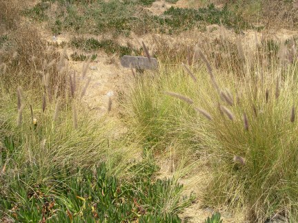
There is a trail there somewhere
This cache was completely exposed when I looked ahead at the bush it resided under. When we left, we hid it just a bit so a casual observer won't see it.
One of the last caches we did before leaving the highlands of La Jolla was on Mt. Soledad. There was lots of trash and dirty clothing strewn around, which was such a shame because the view is fantastic. If I had been by myself, I don't think I would have walked the few feet down the trail to the cache location because it was so icky there.
We finished up two Virtual caches in La Jolla at about 8:00 at night and then found two more caches in Pacific Beach well after dark. Each of these are in areas where your presence is very evident during the daytime, and searching could attract attention from muggles. We had a couple of vagrants sitting on the sidewalk at one of the Ma Bell caches, but the two of us were able to complete the task without them being any the wiser.
Finding caches like those after dark, and with another person, is much easier than trying to find them on your own. In fact, I probably wouldn't have most of my "urban micros" in my "Found" list if P.T. hadn't been with me.
I really thought the cache was going to be attached to a rock, or piece of concrete, and well-cammoed in that way, so I was surprised to find a container favored by Duscwe! hidden beneath something mentioned in the hint. The extra hint from Carl helped because our GPSrs had us looking a bit further to the south on our original hunt.
From there we headed toward Tecolote Canyon and Devhead's "Tecolote Challenge." This was going to be P.T.'s third visit to the canyon, so she is really getting to know those treacherous washouts and the other twists and turns in the trail. Devhead provided some updated coordinates, but under that heavy tree cover, I'm not sure how helpful they were. However, someone in the Forums had been asking about hiding caches "in the air," so that got me to look up, and that is where the cache was. You had to climb up the tree to get it down from the little rope cradle it was resting in.
I launched my new Travel Bug in this location. I picked up "Consistent Compass" at the Boy Scout cache off Regents road last week.
The rest of our day took us to some of the most scenic locations in the San Diego area in La Jolla and finally up on Mt. Soledad. We went to the "Thank You, San Diego" cache, and the "Vintage: Coast PB Jar," which is one of the oldest caches in the San Diego area.
The views from both caches were astounding, although the day was a bit hazy. This is a spot to keep in mind for one of those crystal-clear days after a rainstorm in the winter.
We made out way to the trailhead for The Spooky Tree and that was quite a walk. The trail follows a "creekbed" that must have been very treacherous this past winter. As it is, it can be treacherous in places because most of the time you are walking on river rock. The tree itself is probably very spooky on a moonlit night. We were surprised the cache was still in place because it looks like a lot of water flowed through the area and around the tree during the near record-rainfall winter.
We went to a cache called KS Tumbleweed. At one time there was a nicely-done nature trail, but it hasn't been maintained since it was created. We managed to navigate the trail, and non-trail, and avoid most of the thistles, but I didn't see a single prickly-pear cactus and walked into it. OUCH!!
There is a trail there somewhere
This cache was completely exposed when I looked ahead at the bush it resided under. When we left, we hid it just a bit so a casual observer won't see it.
One of the last caches we did before leaving the highlands of La Jolla was on Mt. Soledad. There was lots of trash and dirty clothing strewn around, which was such a shame because the view is fantastic. If I had been by myself, I don't think I would have walked the few feet down the trail to the cache location because it was so icky there.
We finished up two Virtual caches in La Jolla at about 8:00 at night and then found two more caches in Pacific Beach well after dark. Each of these are in areas where your presence is very evident during the daytime, and searching could attract attention from muggles. We had a couple of vagrants sitting on the sidewalk at one of the Ma Bell caches, but the two of us were able to complete the task without them being any the wiser.
Finding caches like those after dark, and with another person, is much easier than trying to find them on your own. In fact, I probably wouldn't have most of my "urban micros" in my "Found" list if P.T. hadn't been with me.
posted by Miragee at
5:23:00 PM
|
0 comments
![]()
![]()


 10-Day Forecast


