Blog Template Musings about Geocaching: 2006-09-10

Musings about Geocaching

Saturday, September 16, 2006

Cameron to the Grand Canyon and on to Prescott

My, what an adventurous day, starting with the fact that when I woke up, the previously-full parking lot was empty . . .

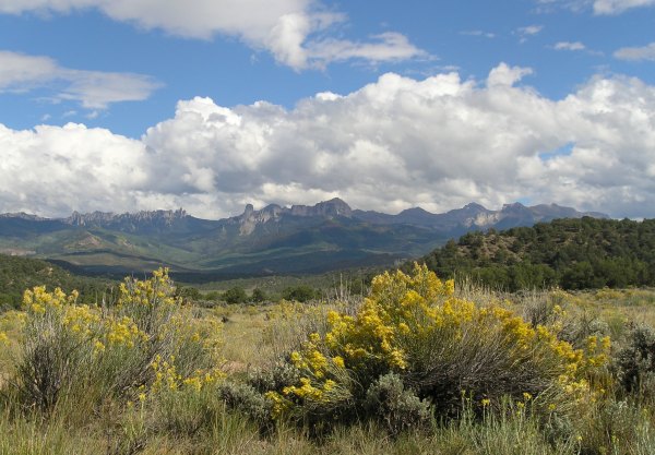
It seemed prudent to get out of there quickly, so I packed up my stuff and hit the highway well before dawn, snacking on some fruit as I drove down Highway 89 to AZ 64 towards the Grand Canyon. That side trip was another impulse decision. I drove right by that road last Spring, but today, I thought, "Why not?" and "When will I have this opportunity again?" As the sun came up, I was at a scenic overlook for the Little Colorado River canyon.


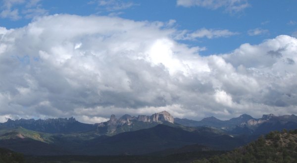
When I got to the the entrance to the Grand Canyon, it was still very early, too early for the rangers to check my pass. The light was beautiful, even if the visibility was not great. However, my pictures came out better than expected. If I had known that, I would have taken more during what turned out to be a quick visit to the park, starting at Desert View, the site of Mary Colter's wonderfully-compatible Watchtower.


After circling around the area where the lodge is located, and where the employees reside, in an effort to figure out how to get to the Virtual caches, I finally realized I would have to take a shuttle bus. The crowded parking lots and large numbers of people walking around in that section of the park overwhelmed me. Waiting around to take a crowded shuttle bus didn't fit with my mood, or my "schedule," so I started south towards Williams, AZ.

At Grand Canyon Village, I followed the arrow on my GPSr to the parking lot behind the National Geographic Information Center. I struck up a conversation with a young man heating water on his camp stove for some hot cocoa. When I told him I was hunting down a Geocache, he said, "I invented that." We talked for a while longer, sharing stories of the road since he was "car camping" like I was.

"Have you found the cache yet?" he asked. I said, "No." He asked, "Can I go with you?"

"Sure," I said, so we set off to walk the 300 feet to the cache. Under the trees my track to GZ was meandering. We arrived above GZ on a little rock outcrop. After turning over several rocks looking for a cache "Buried under rocks," according to the hint, I called it a DNF. It was a beautiful day, but I didn't want to spend any more time looking, at least not until I had my morning coffee.

After going inside the building and getting a cup of coffee, I walked back up the hill, this time by a much more direct route, and this time, I found the cache to the NE of GZ by about 20 feet. With that success, I wanted to share it with my new acquaintance. I wandered around the large building for a while before finding him. I said, "I found it." Of course, he wanted to see it. So, for the third time, I walked up the little hill. Good thing the cache was only a few hundred feet from the parking lot . . .

He signed the logbook as a "converted muggle." After talking some more, we set off separately down the highway. He was headed towards Sedona for some mountain biking, and me . . . well, I didn't know where I was going to land that day.

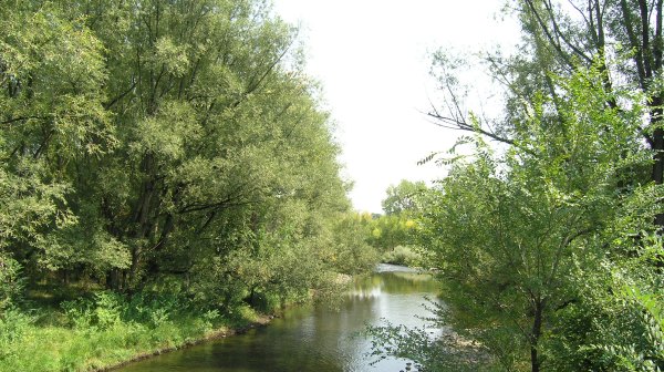
Before getting to the historic Route 66 town of Williams, I took a little hike around Kaibab Lake to find a classic ammo-can cache.


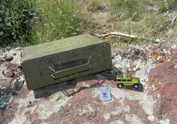
The walk was about half a mile from where I parked my car, and the last 300 feet to the cache was steep enough that the effort really got my heart pumping, something I needed after all the hours of sitting and driving over the past eleven days. Since the cache was supposed to have several TBs in it which weren't there, it didn't seem like a prudent place to leave the GJTB.

When I got to Williams, AZ, I drove up and down the 15-mph one-way streets taking in the sights along the old Route 66.

After spending some time there, getting the information for the "Eight Cribs" Virtual in town, and taking some pictures for potential Waymarks, I took off down Highway 89 toward Prescott, a town I drove through almost 19 years ago with three horses in my 18-foot-long horse trailer.

At that time, in my "other life," I was on my way to Wickenburg and the Wickenburg Inn guest ranch where I would spend the winter. Back then, I could still recite Gail Gardner's famous poem about the "Sierry Petes," the devil, and Whiskey Row, a poem I first heard recited on my 1985 trip to the Cowboy Poetry Gathering in Elko, Nevada.

On this trip to Prescott, I wanted to become more familiar with the town that has had a such colorful history.


Friday, September 15, 2006

It rained all night, so I wanted to head south to better weather

In 1976, I seriously considered moving to Durango. In August of that year, I spent a long weekend there, camping at the KOA campground north of town. Because Durango is such a wonderful town, I wonder what sort of twists and turns my life would have taken if I had moved there . . .

This morning, as much as I would have liked to stay and absorb more of the town's energy and revisit its wonderful 19th and early 20th century architecture, the weather convinced me to drive east, and then south to Aztec, New Mexico.

Just outside Aztec, I stopped to get a small cache that had a tiny little teddy bear in it. For some reason I really like these tiny swag items, so I traded for it, and for the rest of the trip, the little bear looked at me from its perch on the beanbag auto-mount for my GPSr.

In town, I looked for one cache and didn't find it. Then, I found a coffee shop, but their WiFi connection wasn't working for me. I met an interesting man who was writing a book about the Anazazi, and maybe that is why I forgot to download my tracks from the GPSr to the computer.

I loaded the GPSr with caches for possible routes I would take and hit the road, not knowing exactly which way I was heading, but letting my GPSr lead me. As I drove along the divided road, I saw a little Geocache treasure chest go by on the GPSr screen. I turned around as soon as I could and drove back to a Trading Post/Pawn Shop where I could make a legal left turn back onto the highway, instead of a marginally-legal U-turn.

However, before I could hunt down the object for the Virtual cache, I needed to use their restroom. When I walked in the place, I didn't know I was going to spend an hour in there marveling at all the activity of the people turning in things to get money, and exchanging money for the things they had pawned a few weeks ago.

Off to one side of the counter where all the activity was centered, there was a small room where lots of old interesting items were on display, some behind glass cases, and some just there, like old chaps and saddles that dated back many decades.


Finally, after purchasing a carved jade turtle, I drove across the highway to hunt down the elusive object I needed to find for the "Pictured Cliffs" Virtual cache.


On my way to GZ, I took this picture of the view of Shiprock way, way off in the distance.


As I got close to the Arizona border, I impulsively turned north on Highway 160 towards the Four Corners Monument Virtual cache. Last spring I drove right by Four Corners, declining to pay the $3.00 fee to get into the Monument, deterred both by the price and the "Warning Signs." This time, I drove five miles out of my way to get to it, but was glad I did because I ran into a Geocacher from Arkansas. We had a nice conversation while "Discovering" each other's coins and he told me about other nearby benchmarks in addition to this brass marker where the four States meet.


This is the picture I had a woman take of me to fulfill the requirement for the cache.


As long as I had driven north, I decided to continue north on Highway 160 to Highway 41, so I could go to Bluff, Utah again. By doing that, I could travel through Monument Valley, a place that captivated me last spring.

I expected that State highway to Bluff to be more scenic than it was, since it somewhat parallels the San Juan River. Along the way, I saw this buckskin horse.


Before I became ill, and disabled, and had to sell my horses, I was partial to buckskins. I had several buckskins over those "years of the horses" and had one when I was in high school. Seeing this guy along the ridge felt like a "sign," so I had to stop and take some pictures. When I finally started down the road, I turned around and was somewhat surprised to see he was with a herd of other horses that were just out of sight on the back side of the hill, none of which were buckskin-colored . . . Why was that buckskin horse the only one I could see on the ridgetop?


Just outside of Bluff, the scenic "bluffs" of its name began.


In town, I "bought" a shower at a nice RV park where they had a sign up saying "Camp Host Wanted." If I had an RV, I would be sorely tempted to take them up on that offer . . . There was also an advertisement for Horseback Rides. Maybe I could get a job with that outfit and step back into the life I used to have back in the late 80's when I took people for horseback rides through the incredible scenery near Kanab, Utah . . .

On my way down the highway towards Monument Valley, I took the dirt road that led to the "trailhead" for "The Seven Sailors." As the gravel road descended into a wash, I remembered the road from last spring. Back then, the wash had some standing water in it so I did not venture any further. This time there was no problem negotiating that part of the road and continuing to a parking area about .4 away from the cache. The walk across the sandy desert through widely spaced vegetation to the paint-can cache container was fantastic. The sun was warm, but the breeze was cool, and the views of the Valley of the Gods were incredible.


At the cache, I was sure glad I had a tool with me I could use as a screwdriver because that paint can lid was on tight and when I tried to use a zipper pull to get it open, all I did was succeed in bending the zipper pull . . .

Soon after starting down the road to Monument Valley, the wind picked up, carrying the sand from the badly-overgrazed range high into the sky and obscuring the views of the monuments. I made my way up a side canyon to the location of a Virtual Cache at "Harry and Mike's Place" where I took this picture, which should have had the same distant view as that portrayed on the plaque.


At Gouldings, I filled up with gas, so I could drive a long distance if I wanted to. However, the sun was slowly dropping lower and lower in the sky. I don't like to drive at night, but didn't know where I could spend the night. Out here on the Indian Reservation, there certainly wasn't going to be a Wal-Mart.

At Cameron, I stopped and went inside the incredible Gift Shop/Trading Post where you can buy a 99-cent refrigerator magnet or $1000.00 necklace. As I walked around, I tried to decide if I should continue driving on to Flagstaff, about an hour away, or stay in the parking lot, something that seemed feasible, since there were quite a few cars in the lot.

After a bit of scouting around the area for the optimal place to park near the lodge or gift shop or nearby post office, I settled on a spot not too far from "Valentine's Bridge." Before settling in for the night, I walked over to that location to get a picture with the necessary information for that Virtual cache.


Thursday, September 14, 2006

The "Million-Dollar Highway" deserves its own entry

Growing up in Colorado, I would only hear the names of two towns, Silverton and Ouray, included in the same sentence. I had been to Silverton in 1976, and remembered riding in the car on that "Million Dollar Highway" when I was a child. However, I had no idea how different the setting was for Ouray compared to the high-mountain community of Silverton.


From the turnoff to Ridgway, the layered sandstone bluffs rise up on each side of the two-lane highway, and then suddenly, the town appears. The buildings that date from the 19th Century are spectacular.


As I took a few pictures, I talked to a young woman who had moved to Ouray two years ago, after visiting the area for several years prior to that. She said "You couldn't pay me to move anywhere else." But then she admitted, "You have to be creative to make a living here."


I really wish the road had not beckoned me. I should have stayed in the old hotel in town. It would have been a wonderful experience, like the time when a friend and I stayed in the old Cody Hotel in Cody, WY. But, alas, I didn't have $50.00 for a room . . .

As I started up Highway 550 out of town, I stopped to get this picture.


Red Mountain certainly deserved its name.


At the very end of the day, in light sprinkles of rain, I found the "Pyramid Spring" cache near this artifact from a previously-commercial hot springs.


In the rain, after dark, I drove through Durango, assuming there was a Wal-Mart somewhere. The big blue sign finally appeared on the right-hand side of the road. I pulled in and found a place to park near the motorhomes and travel trailers already parked there. After a quick trip inside the store to brush my teeth and get some bananas for breakfast, I unpacked my sleeping bag and settled in for the night, falling asleep to the sound of the rain on the roof of my car.


A very early beginning to a late start on the highway

At 4:11 in the morning, I woke up. For more than an hour, I tried to fall back to sleep, but without success. Finally, I wriggled out of my sleeping bag and stuffed it in the stuff sack and packed everything away. A kind Wal-Mart employee let me in the store before it opened so I could use the restroom, wash my face, and brush my teeth.

I drove down Highway 50 to a restaurant that was open at 6:30 in the morning and treated myself to an omelet. On the four-day trip up to Lakewood, I didn't eat in any restaurants. Other than some bananas and grapes I bought along the way, I only ate food I brought with me, including nuts and dried fruit, and beans and rice I prepared ahead of time. For this homeward leg of the adventure, I did not have an opportunity to prepare any food. Sitting inside the country-chic-decorated restaurant was a treat for me.

By the time I finished my breakfast, the Sacred Ground coffee shop was open. They have a decent WiFi connection, and it is a lot more comfortable sitting inside that place than it is sitting in my car in the Days Inn parking lot. I downloaded my tracks and waypoints from the GPSr to the laptop, and loaded Geocaches for my route for the day, which was going to take me over Monarch Pass towards Montrose and somewhere beyond there.

At the coffee shop, I struck up a conversation with a man I saw there last spring. He uses the computer in the shop to check on foreign-currency investments. His kindness during our discussion was at odds with his reticent demeanor which made me hesitant to strike up a conversation originally, something that comes very naturally for me when I am traveling.

Finally, after finishing my coffee and packing up the laptop, I was ready to hit the road. But just then, a woman came in to ask me about my car, a 2003 5-speed Toyota Matrix, and the gas mileage it gets. As we talked, it turned out we had quite a bit in common, so we talked for more than an hour. By the time I finally started down the road, so many hours had elapsed I didn't try to reverse my DNF for "First Anniversary Cache" up on 'S' Mountain, nor make the hike to another cache on the east side of Salida.

The views along my route over the pass and down the other side, were incredible. There were puffy clouds in the sky to accent the aspen trees which were starting to turn from green to yellow and orange. It was early enough in the process that none of the trees had lost their leaves yet. This picture was taken near "Fooses Creek Cache, one that was placed in 2002.


Outside of Montrose, I stopped for a little guard rail cache, "Woodgate Wetlands Cache. When I pulled into the turnout, I saw the cutest little deer look up at me from the meadow below. I reached for my camera, but the deer got spooked and took off . . . along with another larger deer that emerged from the brush. They bounded away like two very large jackrabbits.

In the small cache container, I was surprised to find a GJTB. Of course I had to take it, so, in "trade" for it, I left nscaler’s CA Poppy Geocoin.

From that cache, I started the incredibly-scenic drive towards Ridgway. I stopped to get the "Alkali Trail" cache I couldn’t find last spring. Since I now knew the coordinates were off, I was able to look around a bit and deduce where it might be hidden. I found it in the rocks, 28 feet away from GZ. I took new coordinates which I hope will be helpful for future seekers, especially those who make the hike from the trailhead, instead of those like me who take the 10-minute "window" of time to race down the trail from the Visitor Center to the cache site. The Visitor Center for the State Park has these astounding views.


It was great to remove the "Alkali Trail" cache from my "As-Yet-Unfound DNFs" Bookmark List and add it to my "Caches with a View" Bookmark List.

A bit further down the road, I walked along a nice hiking and biking trail to find a cache hidden near this old Dallas Townsite wooden waterpipe.


This was another artifact I saw along the trail.


The pretty clouds from earlier in the day were coalescing into storm clouds, and when I got to the turnoff for Ridgway, there were a few raindrops slashing on the windshield. I dodged them as I walked over to get the Galloping Goose #1 Cache" at a little outdoor Railroad museum.

That area is so astonishingly scenic, I wish I had stopped driving and found a place to stay. However, the elevation there is more than 7,000 feet. With threatening skies overhead, I thought I should keep traveling south in hopes of finding clearer skies and warmer weather.

My next stop along the way was Ouray, Colorado, a town with a setting so astonishing it brought me to tears. I took lots of pictures of it, and of the scenery along the "Million Dollar Highway" to the mining town of Silverton.

That part of the drive today deserves its own Blog Entry.


Wednesday, September 13, 2006

Heading back, very slowly, to San Diego County

After taking my sister to the airport, it was time to go caching.

I found a cache in which I could leave a couple of Travel Bugs, on of which was very cute. I thought it was appropriate to leave "The Original Donald" lakeside where other ducks congregated.


From there I followed the arrow on my GPSr to a Virtual cache. As I turned the corner in that old, somewhat rundown section of Denver, I was astonished at the view of this enormous, domed structure. I think I said outloud, to myself, "What is THAT?" It turned out to be the old Carousel building from the famous Elitch Gardens amusement park that has succumbed to progress through redeveloping to high-density housing and condos. It sure didn't look like progress to me, but I'm glad they didn't tear down this amazing structure, nor the nearby theater building, which is being restored.


From there, I found a cache in Lakewood where I finally released Toby's Gang's Maui coin T.B. I hope it has safe travels and doesn't get stalled again. The cache I put it in was near this section of Clear Creek, the creek that is the source for that "pure Rocky Mountain
Spring water" that is the basis for Coors beer.


I tried again to find the "Cool Tooth Fairy" cache, and after poking around where the coordinates led me to someone's backyard, I gave up. Other people find it and say they "get" the name reference, but I've tried to find it three times now. Nothing new, I had several DNFs while in the Lakewood area.

Finally, it was time to hit the road if I was going to make it to Salida by nightfall. But, I had to find a few more caches along the way. I still had some Travel Bugs with me and I wanted to drop them off before I started heading west again.

This cute guy went into "Mother Nature's Wardrobe Malfunction."


This was the "malfunction."


At another cache along Highway 287, I took pictures of nscaler's CA Poppy Geocoin with a beautiful Rocky Mountain backdrop. The coin had been traveling with me all along the way. I was hesitant to drop it since the last three Geocoins I had in my possession were stolen as soon as I released them . . .


Just up the road I found a cache near this amazing, relocated Hot Dog stand. Since the object of interest for the cache was such a cool find I wouldn't have noticed if the cache had not been there, I impulsively decided to leave the GJTB that had been traveling with me since the first day.


Near the end of the day, I stopped to take in the view across a wide valley.


When I got to Salida, it was after dark, but still early. I pulled into the Days Inn parking lot, opened the laptop, and logged onto GC.com. I logged the caches I found that day and logged the Trackables. I browsed around the Internet a bit and checked into the San Diego Thread of the Groundspeak Forums before finally heading back to my "campsite" at the Salida Wal-Mart parking lot.

I didn't realize how comfortable my car could be, and how secure I would feel, "camped" like that. However, if you ever need to camp like that, don't forget to bring earplugs. That night, a diesel truck had the engine running all night long . . .


Web Counters
Office Max Coupon