Finally, a visit to the world's longest curved trestle
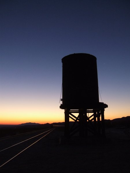
My alarm clock went off at 3:15 in the morning. I got up, got ready, and met fisnjack at 4:45 at the Descanso Park 'n Ride for the long drive out to the Mortero Palms campsite to meet up with Eric and Hill and The Polar Bear. On the drive to the campsite, fisnjack stopped so I could get out and take a picture of the water tower, an object I first photographed more than 30 years ago.
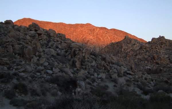
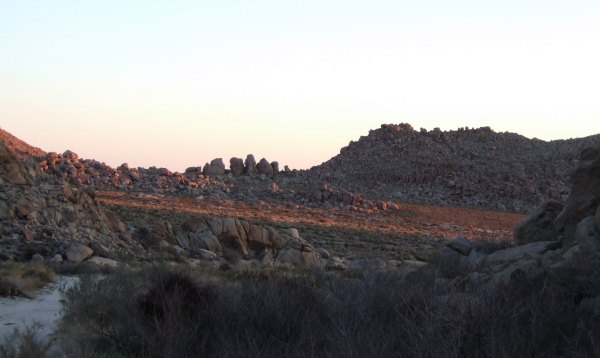
We continued down the bumpy, washboarded road and arrived at dawn. While the guys finished getting ready, I took some pictures of the dawn light.
When we set out on the trail, it was still very cold. I was bundled up with fleece gloves, a fleece jacket, and a fleece vest, while Eric and Hill started off with no jacket, not even a long-sleeved shirt . . . Brrrrrrr!
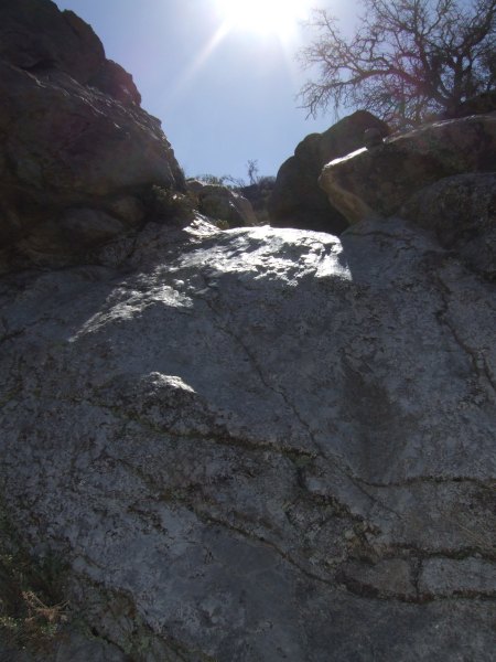
Near the beginning of our hike in and just past the palm oasis, the going was tough. There were large boulders, and slick "waterfall" slides I couldn't have made it up without the help of my companions. Finally, the trail opened up and it was easier going. We just had to watch out for those nasty cholla cactus that were just waiting for a bit of inattention so they could attack.
The first cache was one placed by my friend CTYankee9 and after we signed the log, we picked up the container, since CTYankee9 did not want the Park Rangers to steal that container like they have so many others since they initiated their new "policy."
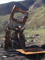
Before leaving the area, we created a memorial at the location of the cache.
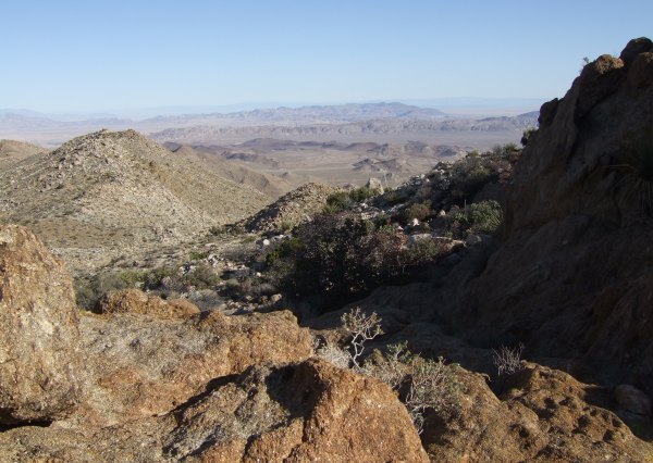
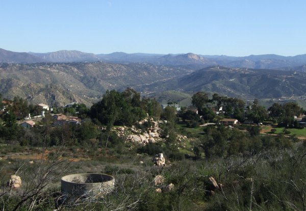
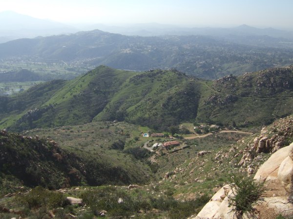
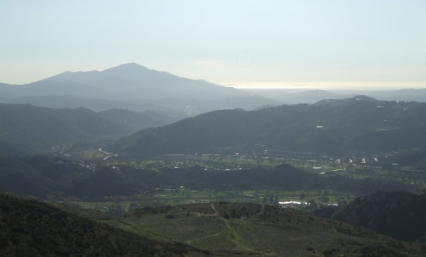
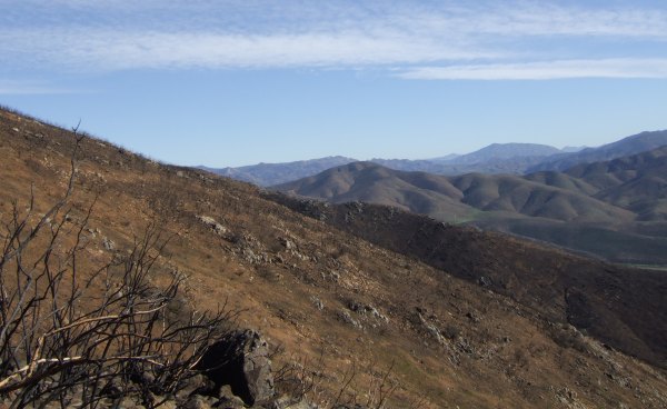
We continued up, up, up the wash and then realized we had to head cross-country to get to a Terracache near "Jacumba 3446." That cache was in a great location that offered views in all directions. This is a view towards the north.
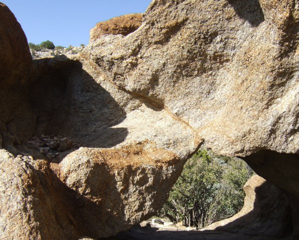
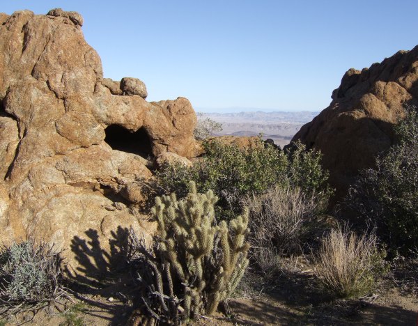
Here is a closeup view of "Dave's Cave."
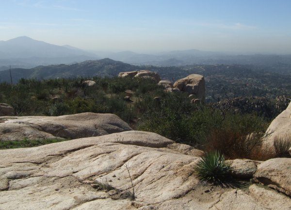
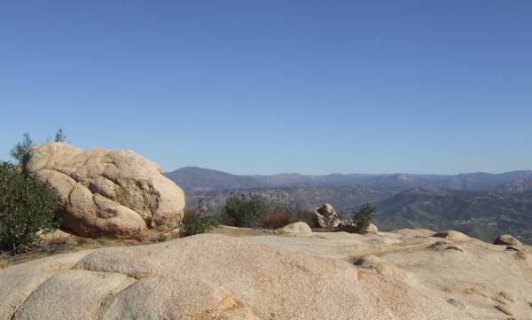
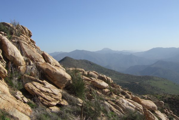
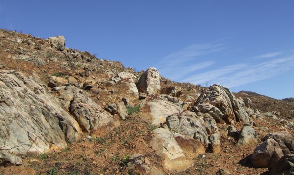
And, here is a view of the great rock formations in the area:
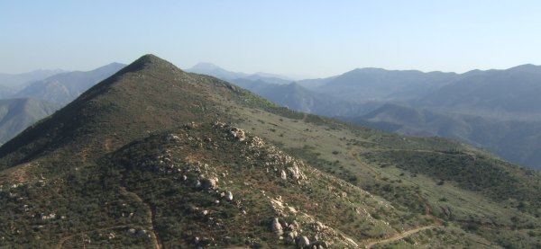
From "Dave's Cave," we walked a short distance to "Jacumba 3446," a cache that was placed in 2001 and one that is on "Version 2.0" of my "Historic Cache Adventures."
On the peak, the breeze was cool, so we hunkered down on the lee side and ate some snacks to fortify ourselves before starting down the other side towards our goal. Before heading down, we picked up the ammo can, so it wouldn't be stolen by the Rangers.
As we headed down into the wash where we were going to leave the two ammo cans, fisnjack stepped on a rock that moved under his foot. He flew up in the air and fell, on his back, on the point of a boulder. I ran to him and said, "Don't get up, don't get up." He didn't listen, said he was okay, and stood up right away. I was amazed he was able to get up . . . it was really a bad fall.
We stashed the two ammo cans and started down, down, down the canyon towards the trestle. Not too far down, there was a "waterfall" so smoothed by the water, Eric and Hill and I both slide down it. I felt like a little kid as I picked up speed just before my feet hit the sand.
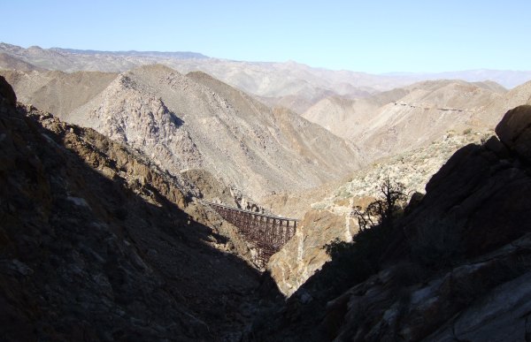
About halfway down, we got our first glimpse of the trestle.
As we continued down, down, down, my legs were feeling quite a bit of fatigue and I worried about how I would do on the way back up. This was definitely the hardest, longest hike I had ever embarked on and I was sure hoping I was in good enough condition to complete this adventure.
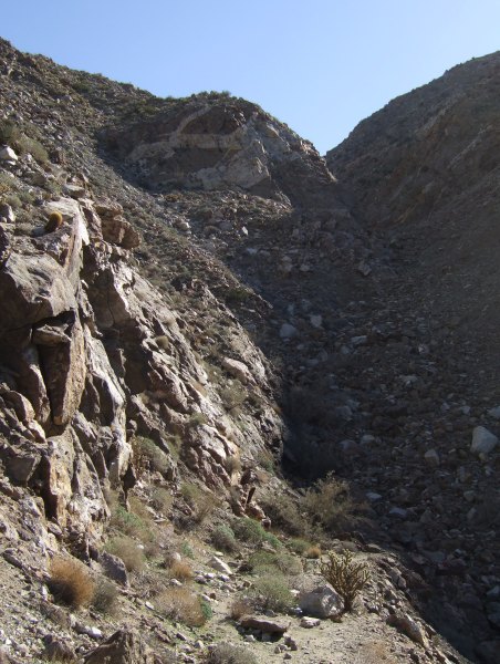
This is the canyon we descended, and had to go back up . . .
We looked for one cache for a long time and came up empty, as had other recent searchers. I wonder if it is a cache the Rangers stole without leaving a Note on the cache page, something they have done many times, which is another reason the level of anger in the Geocaching community is so high. The sudden change in policy, without adequate notice, is one thing. Stealing the caches and then not noting the cache containers have been taken is beyond rude.
To get to the Geocache, we took the "easy" way, although if you are afraid of heights, that is not really easy at all.
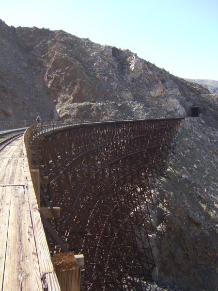
The cache on the other side of the canyon was placed in 2001 and offers the most incredible view of the trestle.
I first learned about this trestle more than 30 years ago and have wanted to see it first hand since then. Finally, I got here, but without the motivation provided by the cache container, I don't think I could have made it. As I have already stated, I am very, very saddened by the new "policy" of the ABDSP "management" and was sorry to see this cache Archived to abide by the cache ban. It is a sad, sad time for cachers who love the desert park and who appreciated the caches that brought us to the special, and spectacular, locations in it.
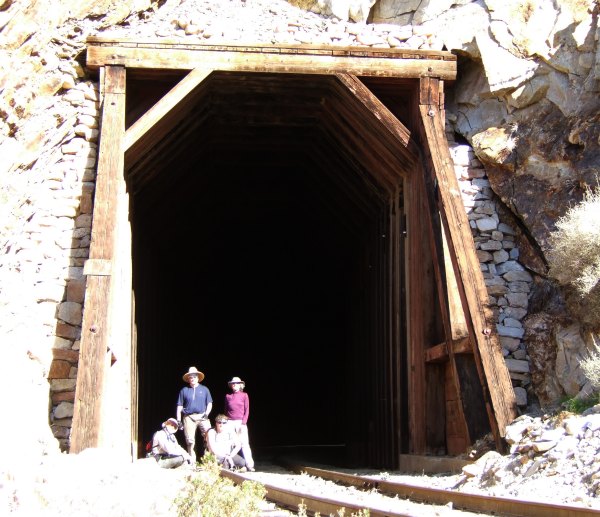
After signing the log in the cache, and retrieving some Geocoins and Travel Bugs, we set out to find a nearby Terracache, but not before taking a picture of our little group in front of the tunnel.
The Terracache was tricky, and dangerous, to get to, and even a challenge for Yukon Jack according to his log in the logbook. That surprised fisnjack since Yukon Jack is the most-experienced Terracacher we know of.
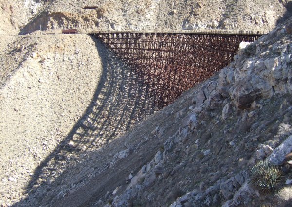
Finally, we started back up the canyon. Before leaving the area, we saw four other people below us crossing over the trestle. At that distance, we couldn't tell if they were possibly other Geocachers, or just hikers out for an adventure on the railroad tracks.
As we started up, the going was slow. I apologized to The Polar Bear, but he said we weren't in a hurry and needed to just go easy. And we did, step by step by step. We did not want any more mishaps. At the top, we picked up the stashed ammo cans and then proceeded up, following Chuy!'s tracks for a while, but then missing them and following a drainage down instead. This offered some challenges in the way of waterfalls and more huge tumbled boulders, but finally, below us, we saw the more well-worn trail. From there, it was less than half an hour back to the campsite and fisnjack's truck.
We visited for a while, and had some snacks before hitting the road. I was very, very tired and was thankful to make it home, take a hot shower, and get in bed for a well-deserved rest.
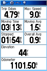
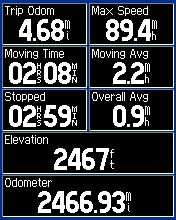
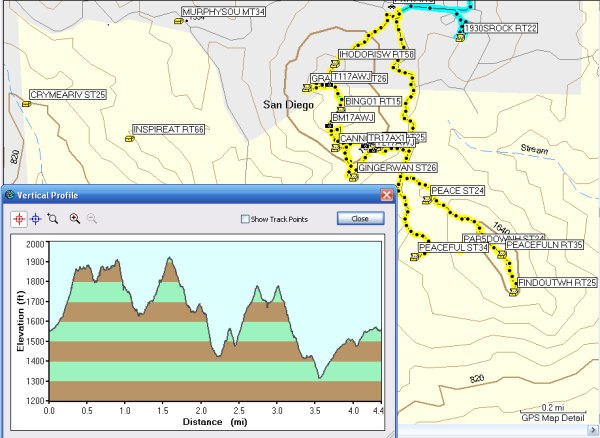
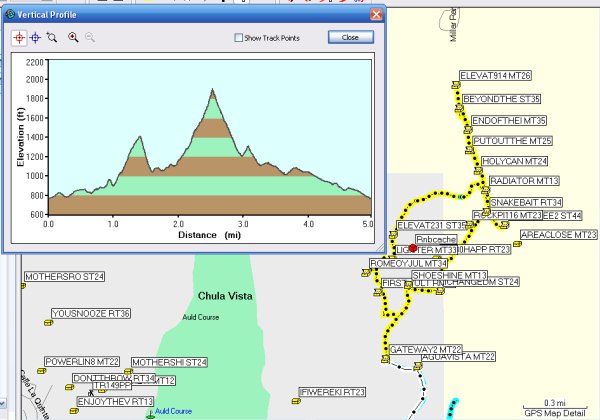
This is the Track and Profile of our hike:

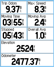
Once again, it did not agree with the Trip Computer. I think I feel like I went the distance shown on the Trip Computer as opposed to the paltry 8.2 miles shown on the Tracks.
It was an absolutely incredible day I wouldn't have traded for anything. My companions were wonderful. They were patient with me when I was slower than they were, and they were patient when I stopped to take pictures. They looked out for me along the entire route and for that I was very appreciative. Of course, as usual, I am very grateful that fisnjack wanted to go and for driving that long distance.
Geocachers are the best people!
We continued down the bumpy, washboarded road and arrived at dawn. While the guys finished getting ready, I took some pictures of the dawn light.
When we set out on the trail, it was still very cold. I was bundled up with fleece gloves, a fleece jacket, and a fleece vest, while Eric and Hill started off with no jacket, not even a long-sleeved shirt . . . Brrrrrrr!
Near the beginning of our hike in and just past the palm oasis, the going was tough. There were large boulders, and slick "waterfall" slides I couldn't have made it up without the help of my companions. Finally, the trail opened up and it was easier going. We just had to watch out for those nasty cholla cactus that were just waiting for a bit of inattention so they could attack.
The first cache was one placed by my friend CTYankee9 and after we signed the log, we picked up the container, since CTYankee9 did not want the Park Rangers to steal that container like they have so many others since they initiated their new "policy."
Before leaving the area, we created a memorial at the location of the cache.
We continued up, up, up the wash and then realized we had to head cross-country to get to a Terracache near "Jacumba 3446." That cache was in a great location that offered views in all directions. This is a view towards the north.
Here is a closeup view of "Dave's Cave."
And, here is a view of the great rock formations in the area:
From "Dave's Cave," we walked a short distance to "Jacumba 3446," a cache that was placed in 2001 and one that is on "Version 2.0" of my "Historic Cache Adventures."
On the peak, the breeze was cool, so we hunkered down on the lee side and ate some snacks to fortify ourselves before starting down the other side towards our goal. Before heading down, we picked up the ammo can, so it wouldn't be stolen by the Rangers.
As we headed down into the wash where we were going to leave the two ammo cans, fisnjack stepped on a rock that moved under his foot. He flew up in the air and fell, on his back, on the point of a boulder. I ran to him and said, "Don't get up, don't get up." He didn't listen, said he was okay, and stood up right away. I was amazed he was able to get up . . . it was really a bad fall.
We stashed the two ammo cans and started down, down, down the canyon towards the trestle. Not too far down, there was a "waterfall" so smoothed by the water, Eric and Hill and I both slide down it. I felt like a little kid as I picked up speed just before my feet hit the sand.
About halfway down, we got our first glimpse of the trestle.
As we continued down, down, down, my legs were feeling quite a bit of fatigue and I worried about how I would do on the way back up. This was definitely the hardest, longest hike I had ever embarked on and I was sure hoping I was in good enough condition to complete this adventure.
This is the canyon we descended, and had to go back up . . .
We looked for one cache for a long time and came up empty, as had other recent searchers. I wonder if it is a cache the Rangers stole without leaving a Note on the cache page, something they have done many times, which is another reason the level of anger in the Geocaching community is so high. The sudden change in policy, without adequate notice, is one thing. Stealing the caches and then not noting the cache containers have been taken is beyond rude.
To get to the Geocache, we took the "easy" way, although if you are afraid of heights, that is not really easy at all.
The cache on the other side of the canyon was placed in 2001 and offers the most incredible view of the trestle.
I first learned about this trestle more than 30 years ago and have wanted to see it first hand since then. Finally, I got here, but without the motivation provided by the cache container, I don't think I could have made it. As I have already stated, I am very, very saddened by the new "policy" of the ABDSP "management" and was sorry to see this cache Archived to abide by the cache ban. It is a sad, sad time for cachers who love the desert park and who appreciated the caches that brought us to the special, and spectacular, locations in it.
After signing the log in the cache, and retrieving some Geocoins and Travel Bugs, we set out to find a nearby Terracache, but not before taking a picture of our little group in front of the tunnel.
The Terracache was tricky, and dangerous, to get to, and even a challenge for Yukon Jack according to his log in the logbook. That surprised fisnjack since Yukon Jack is the most-experienced Terracacher we know of.
Finally, we started back up the canyon. Before leaving the area, we saw four other people below us crossing over the trestle. At that distance, we couldn't tell if they were possibly other Geocachers, or just hikers out for an adventure on the railroad tracks.
As we started up, the going was slow. I apologized to The Polar Bear, but he said we weren't in a hurry and needed to just go easy. And we did, step by step by step. We did not want any more mishaps. At the top, we picked up the stashed ammo cans and then proceeded up, following Chuy!'s tracks for a while, but then missing them and following a drainage down instead. This offered some challenges in the way of waterfalls and more huge tumbled boulders, but finally, below us, we saw the more well-worn trail. From there, it was less than half an hour back to the campsite and fisnjack's truck.
We visited for a while, and had some snacks before hitting the road. I was very, very tired and was thankful to make it home, take a hot shower, and get in bed for a well-deserved rest.
This is the Track and Profile of our hike:
Once again, it did not agree with the Trip Computer. I think I feel like I went the distance shown on the Trip Computer as opposed to the paltry 8.2 miles shown on the Tracks.
It was an absolutely incredible day I wouldn't have traded for anything. My companions were wonderful. They were patient with me when I was slower than they were, and they were patient when I stopped to take pictures. They looked out for me along the entire route and for that I was very appreciative. Of course, as usual, I am very grateful that fisnjack wanted to go and for driving that long distance.
Geocachers are the best people!
posted by Miragee at
9:23:00 PM
|
1 comments
![]()
![]()

 10-Day Forecast


