Blog Template Musings about Geocaching: 2005-06-05

Musings about Geocaching

Wednesday, June 08, 2005

Seventeen caches in one day . . . Wheeeeuuuu!

We started out in El Cajon at a cache I had sort of looked for once before. Actually, because there were some people across the street, I really hadn't given "View of 67" a real thorough look, but since the coordinates were off by quite a bit, even if I had, I wouldn't have found it that first night.

So, since Princess Toadstool had found it before, she gave me a bit of guidance on this one, and while I signed the log, she found GZ with my GPSr and that's when we saw that it was off by more than 36 feet. This is one of those cases where I just wonder if someone got mixed up and put the ammo can beneath a different tree after grabbing the loot and signing the log in their car.

From there we drove up the 67 to a FATTBOY cache called the "END OF THE LINE." (All his caches are written up in all CAPS like he is shouting at us to "GET OUT THERE AND FIND MY CACHES!" This one was very cool. A unique container in a location where it only stands out to Geocachers.

On up the road a ways was the Woody Woodpecker series by Splashman and Splashette. We sure did these the wrong way, but I think it was because we came up from the south. The first one in our GPSrs was actually the number three cache. If you came from the other direction, "Parking for Woody Woodpecker" would have come up as "closest." So, we had an initial false start up a road where all the property is private, but I got these interesting pictures along the way:


Do you think there are enough locks on this gate?


This huge horse was the guardian of the garden. I wonder what passing motorists, who happen to see it out of the corner of their eye, think about this giant.

We returned to the car after our little Private Property misadventure and found "Parking for Woody Woodpecker" in our GPSrs. So, after risking our lives crossing the busy four-lane highway first in one direction and then back the other way, we put that cache in the "Found It" column. Then, we finally found a sign that led us to a trail which led us to cache number three. Hmmmm. Cache number two was behind us and rather than backtrack in the morning heat, we decided to get it on the way out.

So, up the road we started. When our GPSrs started going up again, we realized we were on the wrong road. So much for the "breadcrumbs" Splashman and Splashette were leaving for us in the form of caches along the correct trail. Insert "clown smilie" here. We did see this beautiful poppy flower along the trail.


And I got this picture of the little pond from the vantage point of the road above.


We finally bushwacked and followed rabbit trails to Woody Woodpecker where Princess Toadstool took a little break in a piece of shade.


On our way back out to the highway, we came across this sign.


After definitely taking the long way around, we walked back in by the fire station and behind it to finally get what should have been cache number two, after "Parking for Woody Woodpecker."

Wheeewwwuuuu! We needed a break. So, we got the car and drove across the way to Old Hwy 67 where we saw what we though were muggles. But no, it just turned out to be TheRamonaGirls replacing the cache we were just going to look for. We introduced ourselves and then off they went. We finished our snacks, retrieved the cache, signed the log and replaced it and took off for downtown Ramona and the several caches offered there. In quick succession we found the new post office, the old post office, the old town hall, and Collier Park. Plus we paid a visit to the Thrift Store where we bought tupperware containers for caches.

We were finally ready to hit the road again and we took off for the cache out by the airport. This one could have been a real easy one except the last people to close the container tightened it so tight we couldn't get it open. Yikes! What to do, what to do? We scratched our initials in the bottom of the plastic container and replaced the cache, but when we got back to the car, we remembered the jumper cables and took them back across the road to use the clamps like pliers to get the cache opened. They worked great, just as they did several months ago for "In Denial," so we were able to sign the log legitimately.

From here we took the back road to 78 to find a brand new cache called "Clevenger Canyon Cache." It was a very neat trail down into a spectacular canyon that was not affected by the fires of a couple of years ago.


There is an archway of rock near the top of the trail.


After finding out we were Second-to-Find and trading some swag, we walked back to the top of the canyon trail and drove back to Ramona and east to Neptune's Deposit. We couldn't find the parking for this one because the restaurant has changed hands and the sign no longer says what the cache description tells us to look for. So, we went on up the road to another cache, which shall remain nameless. It had one of the worst placements for a cache I have seen. It was on a busy stretch of highway and had no redeeming feature I could see. I think it may have been placed as a joke on someone. Maybe the joke was on us since we did park and walk to it to sign the log.

At the end of a long day, we found a cache Princess Toadstool had tried to find two other times. It is not in the best of locations, but it is a clever hide and this time she found it right away. I was the recipient of her good fortune this time because I'm not sure I would have caught on to that location for the cache.


Some twelve hours after I left my house I arrived back home with just enough energy left over to log all the caches before crashing for the night.
Tuesday, June 07, 2005

No wonder "city folk" can find so many caches

I was in San Diego for my first Humphrey's concert of the season and while I was near Shelter Island, I thought I'd try to find some caches. So, an hour later, I had five caches found, and one DNF -- all in the time it takes me to drive to the "Park and Ride" out in the East County to meet up with Princess Toadstool or gvm to do some caching out here.

No fair!!

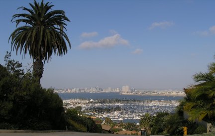
Actually, it was a beautiful afternoon and even though I've been down that way a lot, I saw it differently because I was looking for caches. I had been on Lucinda Street a couple of years ago when I got a new camera, but it was good to go back and take another picture from that excellent viewpoint of the "Big Bay" and the San Diego Skyline.


The last cache of the day was "Hearts of America" which was supposed to be a heart-shaped Altoids tin. Maybe the "heart-shaped" one got borrowed for something because this is a typical rectangular, non-camouflaged, red, black and white Altoids tin.


The one cache for which I had a DNF was supposed to be a cylindrical container "next to the thing that is next to the thing that is bright red." Hmmmmmm! Well, I didn't see anything that fit that description, however my GPSr sent me to this location.


Today someone logged a find on that one for the previous day, but they said they didn't sign the log because it was so "wet." Guess I'll have to check with FlagMan about that one.

I did, however, find his "Rosecroft Gardens" cache which was well-camouflaged, although stinky, because it has that lovely creosote smell. So, at least I know I'm not blind.

At the "Grandparents's Cache," I started feeling a bit conspicuous after walking back and forth to the car and up the path for several minutes.

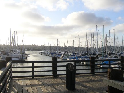
I took a couple of pictures then reluctantly left the area, however, in a more rural location, I would have spent more time looking even more thoroughly.

Sunday, June 05, 2005

My newest map from Keen People for San Diego Finds


Latitude Used:33 Longitude:-116.5
Zoom Width 1 degrees by 1 degrees.

(Unfortunately, just after I uploaded this .gpx file to the Keen People site, their maptool stopped working. I just tried again because today, July 17, was my six-month "lunaversary" and I still get the same picture back even though I have found more than twice as many caches as show on this map.)


The Old Burma Road and numerous caches were calling

This is the time of the year when the temperature can vary from 100 degrees to the mid-70s depending on how far inland the "coastal low cloud and fog" extends. Saturday was one of those mild days perfect for catching some "inland" caches that will be inaccessible in a few weeks because of the heat.

So, once again I drove over to the "Park and Ride" near Descanso to meet a friend. He has a new van and was willing to drive up the roads in the Laguna Mountain/Sunrise Highway area. The closest cache we saw in our GPSrs was north of Pine Valley. It was a surprise to see this little one-lane road was paved. Had I known that, I could have driven my car.

The first cache we got to was "easy peasy." It was a small container inside a 4" diameter pipe. However, the last people to put it away, put it way inside the pipe. It is a good thing I have very long arms or I wouldn't have been able to reach it. The next cache was "in a bush" according to the hint. So, I took the hint literally and thought it might be another one of those DeCon containers hanging from a branch in one of the four or five bushes near GZ.

There were a bunch of biting flies bothering us as we conducted our ever-lengthening search. I read and re-read the past logs and then somehow saw the ammo box on the ground "under" the bush.


I know it is a manner of semantics, but I would have written the hint differently. That was another example of taking the available information too literally, something I have a tendency to do with most everything.

One cache had a great view to the west. It also gave us a nice look at all the new growth after the devastating fires.


Some of these thistle blossoms were nearly two inches in diameter.


We missed the turnoff to one cache because of the limited parking available, but we found a nice hike in the trip to T.R. Violin's "Big Tree Down" cache. As we bushwacked through the high grasses, the sound of water drew us over to this little waterfall.


After finding the horse gate, I wanted to walk up to the big tree, since that was the reason T.R. placed the cache. He said he discovered the tree some 30 years ago. It must have been spectacular, and it is too bad the fires of October 2003 finally caused its demise.


We walked back to the horse gate and started our search for the cache. I was just going to check the past logs in my Palm again when I heard and odd tapping sound. My friend had found the container under a nearby bush while searching with the walking stick.

I took some pictures of this spectacular tree on the way back to the car. Maybe another cache should be placed near it to celebrate the fact that it is still standing.


We finally reached the end of the Old Burma Road and started back, but then a cache showed up in my GPSr only .3 mile behind us. So we turned around and found the Kwaaymii High View cache.


Last spring I met a couple in Joshua Tree National Park who told me they like to take pictures of their shadows. The late light gave me an opportunity to get a self-portrait.


The late afternoon light accented the beauty of the unique rock formations and this yucca growing in the windswept area of this spectacular viewpoint.


Our last cache of the day was one by Duscwé! It was located at a viewpoint platform that had been built so even people in a wheelchair can see the awesome view of the desert below.

Finally, in fading light and with the headlights on, we gave up the search for caches search and headed home for the day.


Web Counters
Office Max Coupon