After getting a new set of tires, I was on the highway
The decision to make the trip to Lakewood was made very quickly, with little lead time. However, I downloaded Pocket Queries for several areas across Arizona, Southern Utah, and Southwestern Colorado, as well as a circle centered in Lakewood. So, with GSAK on my laptop all loaded with fresh data, I was ready to go . . . just as soon as I got new tires. My old ones were measuring in the red when the man from Discount Tire checked them for me.
When I went down to have the tires checked that Thursday afternoon, I filled the tank. Now, on my way out of town, I was shocked to see that in less than 12 hours, gas had gone up another ten cents. I sure hoped gas would be less expensive along the way, and I was very, very grateful my sister was going to help me pay for the gas.
The reason for the trip was to help my mother clean and organize her apartment. She is 90 years old now. As I drove down I-8, I was very lost in thought about her future -- and my own -- when a car passed me on the left. An arm was waving a GPSr out the window of the vehicle as it went by.
I shook myself of of my thought daze and caught up to the vehicle to see that the arm belonged to $kimmer. She was with The Vulture and said the Splashes were up ahead. They were on their way to "Dateland," the first cache I had planned on stopping for.
We pulled into the parking at the famous Date Shake Shop and proceeded to tell the people sitting near the cache location we were on a "Scavenger Hunt" as we looked for the micro. Splashman made the grab and my name was added to the logbook.
From there, the five of us headed down the highway where we found two more caches. At the last one, Splashman pulled into the third parking spot from the end, The Vulture pulled into the next one, and almost simultaneously, I pulled into the last spot. It was precision parking at its best.
After finding that cache, we parted company. They were headed up to Phoenix for a weekend of caching. I was headed somewhere to camp for the night.
As usual, I hadn't planned where I would spend the night -- I'm almost incapable of planning, except when it comes to the preparation necessary for Geocaching -- so I didn't know where I was going. Fortunately, I found some BLM land not too far from the road to Mobile and set up my tent there where I saw a nice Arizona sunset.

The next morning I headed northeast. Once again I really didn't know exactly which highway I wanted to take, so I just followed the GPSr arrow to a couple of cache sites. The first two I tried to find . . . I couldn't, so I went in a Goodwill store and got a "treasure" there before finally hitting the highway again.
The road climbed up past Saguaro cactus and finally into Pinyon and Junipers, the habitat Edward Abbey referred to as the "pygmy forest," and finally up into cool, wonderful pines. I found a few caches in the "Rim Country" where there were signs warning about elk crossing the highway. I didn't see any elk, but late in the day, and I headed towards Canyon de Chelly National Park, I saw a mountain lion run across the road and up the steep embankment. That was exciting!
I loved the town of Holbrook, AZ, and even turned around and drove back over the bridge to take a picture of an amazing sculture at the entrance to the town.

I also took a picture of this great mural.

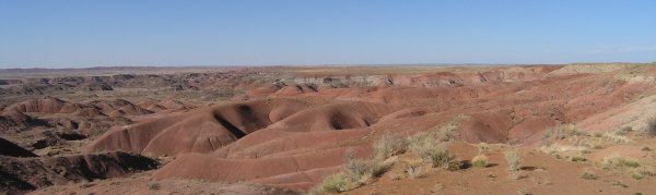
From Holbrook, I headed to the "Painted Desert" Virtual cache where I tried to photograph the amazing landscape.
I got to a campsite at dusk, which was the same time I found my campsite the night before. In the sheltered area of the campground, the wind was calm, so I set up my tent and went to sleep beneath tall cottonwood trees that were just beginning to show new spring leaves.
When I went down to have the tires checked that Thursday afternoon, I filled the tank. Now, on my way out of town, I was shocked to see that in less than 12 hours, gas had gone up another ten cents. I sure hoped gas would be less expensive along the way, and I was very, very grateful my sister was going to help me pay for the gas.
The reason for the trip was to help my mother clean and organize her apartment. She is 90 years old now. As I drove down I-8, I was very lost in thought about her future -- and my own -- when a car passed me on the left. An arm was waving a GPSr out the window of the vehicle as it went by.
I shook myself of of my thought daze and caught up to the vehicle to see that the arm belonged to $kimmer. She was with The Vulture and said the Splashes were up ahead. They were on their way to "Dateland," the first cache I had planned on stopping for.
We pulled into the parking at the famous Date Shake Shop and proceeded to tell the people sitting near the cache location we were on a "Scavenger Hunt" as we looked for the micro. Splashman made the grab and my name was added to the logbook.
From there, the five of us headed down the highway where we found two more caches. At the last one, Splashman pulled into the third parking spot from the end, The Vulture pulled into the next one, and almost simultaneously, I pulled into the last spot. It was precision parking at its best.
After finding that cache, we parted company. They were headed up to Phoenix for a weekend of caching. I was headed somewhere to camp for the night.
As usual, I hadn't planned where I would spend the night -- I'm almost incapable of planning, except when it comes to the preparation necessary for Geocaching -- so I didn't know where I was going. Fortunately, I found some BLM land not too far from the road to Mobile and set up my tent there where I saw a nice Arizona sunset.
The next morning I headed northeast. Once again I really didn't know exactly which highway I wanted to take, so I just followed the GPSr arrow to a couple of cache sites. The first two I tried to find . . . I couldn't, so I went in a Goodwill store and got a "treasure" there before finally hitting the highway again.
The road climbed up past Saguaro cactus and finally into Pinyon and Junipers, the habitat Edward Abbey referred to as the "pygmy forest," and finally up into cool, wonderful pines. I found a few caches in the "Rim Country" where there were signs warning about elk crossing the highway. I didn't see any elk, but late in the day, and I headed towards Canyon de Chelly National Park, I saw a mountain lion run across the road and up the steep embankment. That was exciting!
I loved the town of Holbrook, AZ, and even turned around and drove back over the bridge to take a picture of an amazing sculture at the entrance to the town.
I also took a picture of this great mural.
From Holbrook, I headed to the "Painted Desert" Virtual cache where I tried to photograph the amazing landscape.
I got to a campsite at dusk, which was the same time I found my campsite the night before. In the sheltered area of the campground, the wind was calm, so I set up my tent and went to sleep beneath tall cottonwood trees that were just beginning to show new spring leaves.
posted by Miragee at
8:51:00 PM
|
0 comments
![]()
![]()


 10-Day Forecast


