Whooo Hoo, another FTF!!
Yesterday, a new cache on Mt. McGinty popped up, "Beyond McGinty." I was way too tired to attempt that long, steep climb after our strenous day of rock scrambling out in the In-Ko-Pah area and even this morning wondered if my legs would hold up on that steep, eroded trail for nearly a mile and a half . . . as the crow flies.
After a bit of breakfast, and replenishment of the caffeine level in my blood, I took off down the hill to the trailhead in that subdivision of million-dollar homes. I was disappointed to see another car parked there and wondered which cacher owned a Honda Odyssey. I was just sure at 9:00 in the morning, even on New Year's Day, someone was already racing for the FTF.
Before I left my house, I put on a short-sleeve t-shirt, a long-sleeved t-shirt, a fleece vest, a fleece 1/4 zip pullover, and a jacket . . . by the time I started on the hike at the trailhead, which is a thousand feet lower than my house, I had taken off all those layers, except the long-sleeved t-shirt, and the short-sleeve t-shirt under it and halfway up the first very steep pitch of the trail, I took off the long-sleeved t-shirt. The light breeze was cool on my bare arms, but the 50° temperature was perfect for that strenuous climb.
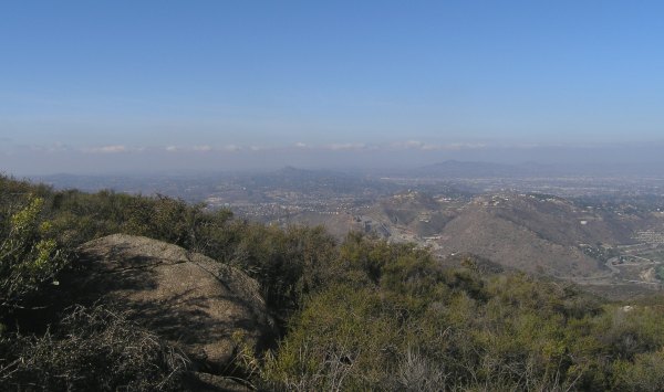
From the cache site, which is quite a way down the other side from the peak, there are views from the west to the north and back around to the east. This is what Mt. Helix looked like through the haze today.
For some reason, the arrow on my GPSr was pointing in the wrong direction as I walked along the road. I could see the little purple line on the map and knew where the cache was in relation to the McGinty Terracache, but my GPSr arrow was pointing off to the east. Good thing I didn't try to follow the arrow the way fisnjack does . . .
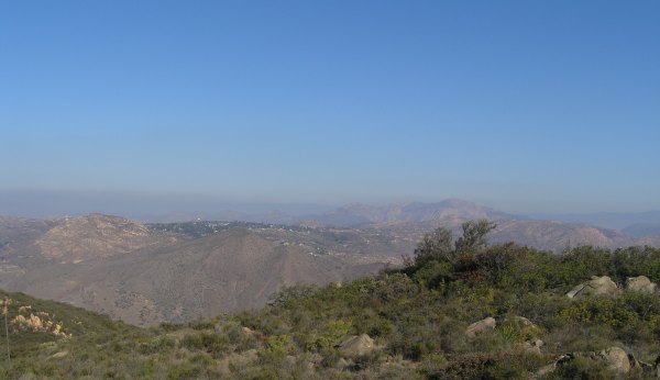
To the north, there is a great view of El Cajon Mountain, the peak I still have to conquer someday.
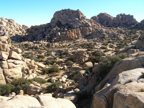
Off to the east, silhouetted in the early-morning light, I could see Lyons Peak, Gaskill Peak, and Sycuan Peak.
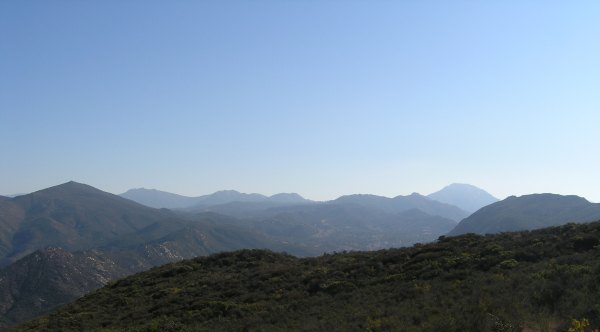
Somewhere out there, in that "back country" between the sharp point of Sycuan Peak on the left hand side of the picture and the broad-shouldered ridge formed by Gaskill Peak, is where I live.
I wish the air had been clearer, as it was the last two times I was on the mountain. I took a few pictures, but the views are much better on Santa Ana days, or days right after a winter storm.
When Princess Toadstool was here in early December and we climbed McGinty, I told her it would be good for me to climb the mountain once a week -- weather permitting. That three-mile hike and climb would sure help me stay in shape.
Today it took me less than 2 1/2 hours to drive from my house to the trailhead, make the hike, and drive back home, so it isn't much of a weekly time commitment . . . however . . .
I hesitate to make that one of my New Year's Resolutions. I would like to make resolutions I might keep beyond the first week of the new year . . .
It is a great hike and on clear days, the views are fantastic. In the spring a wide variety of wildflowers provide a visual treat, and even on winter days like today along the trail there is the occasional aromatic bouquet of lavender and sage in the air.
My thanks to "lostguy" for placing a cache that got my new year started out right. And, thanks for the FTF $$$! The next coffee at Starbucks is on me.
After a bit of breakfast, and replenishment of the caffeine level in my blood, I took off down the hill to the trailhead in that subdivision of million-dollar homes. I was disappointed to see another car parked there and wondered which cacher owned a Honda Odyssey. I was just sure at 9:00 in the morning, even on New Year's Day, someone was already racing for the FTF.
Before I left my house, I put on a short-sleeve t-shirt, a long-sleeved t-shirt, a fleece vest, a fleece 1/4 zip pullover, and a jacket . . . by the time I started on the hike at the trailhead, which is a thousand feet lower than my house, I had taken off all those layers, except the long-sleeved t-shirt, and the short-sleeve t-shirt under it and halfway up the first very steep pitch of the trail, I took off the long-sleeved t-shirt. The light breeze was cool on my bare arms, but the 50° temperature was perfect for that strenuous climb.
From the cache site, which is quite a way down the other side from the peak, there are views from the west to the north and back around to the east. This is what Mt. Helix looked like through the haze today.
For some reason, the arrow on my GPSr was pointing in the wrong direction as I walked along the road. I could see the little purple line on the map and knew where the cache was in relation to the McGinty Terracache, but my GPSr arrow was pointing off to the east. Good thing I didn't try to follow the arrow the way fisnjack does . . .
To the north, there is a great view of El Cajon Mountain, the peak I still have to conquer someday.
Off to the east, silhouetted in the early-morning light, I could see Lyons Peak, Gaskill Peak, and Sycuan Peak.
Somewhere out there, in that "back country" between the sharp point of Sycuan Peak on the left hand side of the picture and the broad-shouldered ridge formed by Gaskill Peak, is where I live.
I wish the air had been clearer, as it was the last two times I was on the mountain. I took a few pictures, but the views are much better on Santa Ana days, or days right after a winter storm.
When Princess Toadstool was here in early December and we climbed McGinty, I told her it would be good for me to climb the mountain once a week -- weather permitting. That three-mile hike and climb would sure help me stay in shape.
Today it took me less than 2 1/2 hours to drive from my house to the trailhead, make the hike, and drive back home, so it isn't much of a weekly time commitment . . . however . . .
I hesitate to make that one of my New Year's Resolutions. I would like to make resolutions I might keep beyond the first week of the new year . . .
It is a great hike and on clear days, the views are fantastic. In the spring a wide variety of wildflowers provide a visual treat, and even on winter days like today along the trail there is the occasional aromatic bouquet of lavender and sage in the air.
My thanks to "lostguy" for placing a cache that got my new year started out right. And, thanks for the FTF $$$! The next coffee at Starbucks is on me.
posted by Miragee at
1:19:00 PM
|
0 comments
![]()
![]()


 10-Day Forecast


