Blog Template Musings about Geocaching: 2006-04-23

Musings about Geocaching

Saturday, April 29, 2006

After five hours on the road, I had driven 48 miles

That's caching for you . . .


That's right. I looked at the clock in my car, then checked the trip meter, which I zeroed out after getting gas just down the street from my mother's apartment, and I had only gone 48 miles in five hours.

I searched for three caches and DNFd each of them. I was beginning to think these Colorado cachers were just too clever for me. Then I finally found one, and another, and in trying to find my way to the correct highway, drove around in a circle, which allowed to to find another cache.

Finally I found Highway 285, the one I was looking for, but didn't find another cache located on a bridge in Morrison. After that, I put some miles between me and the next cache, a fun one called "Turkey Creek To." I had to cross over a small creek to get to the other side and the cache. It was a fun little adventure on a very beautiful day.

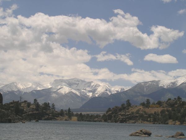
The scenery was incredible along this highway I hadn't traveled in many years. On my way to "Spooky Bat Cave," I saw this amazing view.


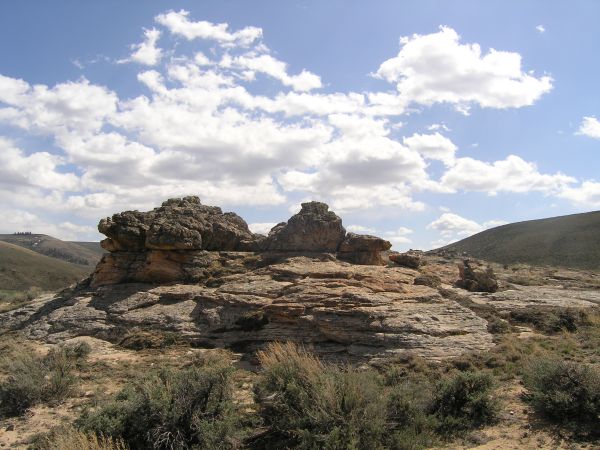
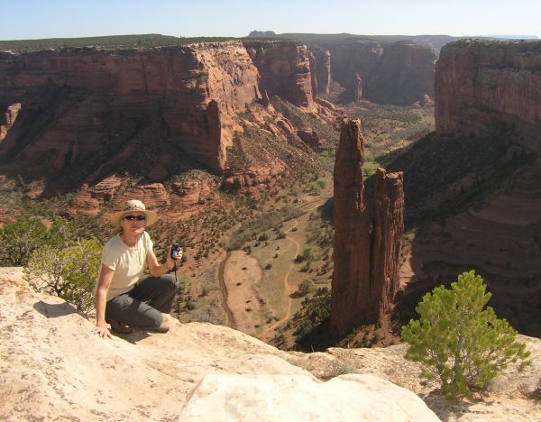
The more I drove that day, on my way to the Black Canyon of the Gunnison National Park, the more fantastic the scenery became. And the weather was perfect for a short 1/2 mile walk to "Cabin Creek Cache" near this amazing rock formation.


I took another couple of short walks to two other caches and maybe that is why I was so tired when I arrived at my campsite that evening. The sun was still up and the late afternoon light on the canyon walls was probably spectacular . . . but I was too tired to budge. I just put up my tent, ate some dinner, bundled up for what I expected would be a cold night at that 8,000' elevation, and went to bed shortly after the sun went down.


Thursday, April 27, 2006

Six days into my adventure and I'm not ready to go home yet

After traveling for four days, and camping out three nights, I finally arrived in Lakewood, CO, in the snow, on Monday. For the past three days, I have been here with my sister helping our mother get her apartment cleaned and organized. I haven't found any caches since Monday. The day before that was when I found a White Jeep in a roadside cache. Boy, was I excited! In my part of Southern California, the White Jeeps are usually only put in really difficult puzzle caches, or at the end of a long hike.

I'll fill in the details later, but the other highlight of my last day on the road before arriving here was the Mirage Trading Co. on Colorado Highway 17 near the Great Sand Dunes National Monument. They had wireless Internet and I was able to log on to get fresh Pocket Queries, and talk to some of the nicest people anyone could hope to meet.


If you're in the vicinity of N 38° 00.017 W 105° 54.530, check out the amazing Alabaster sculptures by Bob Wheat, as well as the other great artwork and jewelry created by several talented people who live in the San Luis Valley.


Monday, April 24, 2006

Finally, I arrive at my destination, in a spring snowstorm

Well, the title of this entry is a little premature, since I still have lots of driving to do to get from Great Sand Dunes National Monument to the other side of the Continental Divide.

The first thing I did in the morning, after packing up my sleeping bag and rearranging all my gear in the car so I could sit in the driver's seat again, was walk all over the sand dunes, taking lots of pictures.

What an amazing place . . . oh, and there was a Virtual cache there as well, "Got Your Buggy."


There were wonderful shadows and forms on the dunes in the early morning light and it was hard to stop taking pictures . . . so I didn't . . . at least not for quite a while.


Can you see the lone figure walking on the dunes in this next picture?


Once I left the beauty of the dunes and the surrounding area, I stopped at the Mirage Trading Post I mention in another blog entry. This was the first time I got to use my new-to-me, used, bought-on-eBay, wireless card on my old laptop computer. It was great to check my email -- I had 80 messages (next time I leave town, I'll turn off the Inta-notify feature . . . Doh!) -- and download a couple of new Pocket Queries at a hundred times faster speed than I get at home with my 24K dialup connection.


After a wonderful visit with several people who stopped in the Trading Post while I was there, I hit the highway again, driving up Colorado 17, north through the expansive and beautiful San Luis valley, towards scenic US 50 and the town of Salida.


Just outside Salida, I saw this amazing Pet Cemetary. It was one of those things you see on the side of the road and just have to turn around for, so you can get some pictures . . .


I really enjoyed the town of Salida. I was trying to find the access to a cache that was very close to downtown, but located at the top of a hill to the east. The cache description talked about the road being a spiral on the map . . . so I knew where I needed to be, I just couldn't figure out how to get over there, and up there.

However, during my search, I found other treasures in town, including a couple of old faded signs painted on the brick buildings, and uniquely-painted water troughs that will soon be planted with flowers, once the spring weather arrives for good.


The problem with traveling on a very-limited budget is the inability to stop and stay when you find interesting places. I would really have liked to stay in Durango to enjoy the town and its architecture, the many more caches there were to find, and the interesting people I saw there.

The same for Salida. I loved the historical buildings and the whimsy of the water-trough paintings, and other interesting sculptures I saw in town.


But, I had to keep moving down the road, so without being able to figure out the cache access, I drove on down the highway toward the spectacular Royal Gorge and its tram and narrow gauge railway.


I was following the arrow on my GPSr as it pointed towards the cache. The arrow did not turn where a dirt road went off the main road, so I didn't even consider that road for access. When I arrived in the main parking lot, I assumed I was supposed to find the trail that would get me the third of a mile up to the cache location.

When I got within a few hundred feet of the cache, that is when I saw the road, and the picnic area . . . Oh well, I needed the exercise, after sitting in the car all day, but it is always somewhat frustrating when you see a road or a trail just a short distance from the cache . . . after you have walked the long way around . . .

Finally, after grabbing a Virtual cache, and discovering a road I wanted to take was closed, I got on the highway in earnest and headed north, running into some bad weather just past Canon City. That light mist turned into snow in Colorado Springs, and even more snow all the way from Castle Rock to Lakewood.

I was sure glad I wasn't going to be camping out that night since the outside temperature was now in the 30's. Brrrrrr!


Sunday, April 23, 2006

Back in Colorado for the first time in sixteen years

After leaving Canyon de Chelly, I drove to Four Corners and into Colorado, the state I was raised in and where I went to college. I moved away many years ago and had not been back since 1990 when I made a trip for medical reasons.

I was going to do the Four Corners Virtual cache, but the cache is on Navajo land and there is a $3.00 fee to get to the Monument now . . .

Although I was traveling on a very tight budget, and hadn't planned on spending $3.00, the fee wasn't the entire reason I didn't proceed. The nearby signs were very off-putting to me. Among other things, the signs said: "Not responsible for bodily injury."

So, I reluctantly turned around and continued on my way, marveling at the fantastic scenery that still looked like New Mexico, but was quickly beginning to look like "Colorful Colorado."

Just outside of Cortez, I found my first Colorado cache, Nature's Preserve. Since I used to own horses, I traded for a little plastic horse I found in the large ammo can that overlooked a little park and lake.

From Cortez, I continued on to Durango, a town I almost moved to in 1976. As I drove around and looked at all the wonderful old buildings, I thought about what my life might have been like if I had moved there. During my brief visit that year, I took a float trip down the river that flows through town.


I found one cache up on a hill near the cemetary. I circled around and around before finally seeing that container.

I tried to find another cache hidden near this very cool suspension bridge, but alas, I couldn't find the micro . . .


I did get some pictures of these kayakers enjoying the beautiful day.


Durango was so inviting on this visit, I had regret about not making the move there so many years ago . . .

After getting a new fuel canister for my little stove at a very cool store like a mini R.E.I., I hit the highway again, heading for a cache at a fantastic viewpoint on Wolf Creek Pass. Since I use the Smart Name feature in GSAK, I often don't read the cache description in my Palm before looking for the cache, so I walked the couple hundred feet to the location and searched and searched and searched for the container that had the "U" designation, for "Unknown" on the GPSr.

The view fromn the cache location was spectacular.


I considered the cache a "Found It" because of that, although I would have logged a DNF . . . that is until I read the cache description. The cache owner changed the cache to a "Virtual," although not officially, because by that time in the evolution of GC.com, new Virtuals were not being approved.

That little misadventure might have taught me to read the cache descriptions before starting the search . . .

I continued my drive, finding a roadside cache with a White Jeep in it! I couldn't believe my fortune. Other than the "precious," the container was nearly empty of swag. As I mention in another post, here in the San Diego area, the Jeep T.B.s are usually only put in very difficult puzzle caches, or at the end of very long hikes.

I also found a cool Virtual cache I wouldn't have stopped to enjoy if it wasn't for Geocaching.


Once again, I didn't know where I was going to spend the night, but I was able to make the drive to the campground at Great Sand Dunes National Monument, after dark, and after seeing some deer on the roadway, and after taking this picture of the fantastic sunset.


After arriving at the campsite, and seeing the bear box, and all the warnings about black bears, I decided not to set up my tent. I rearranged all the stuff in my car so I could sleep in it . . .


Canyon de Chelly National Park is awesome!!

I woke up on the third morning of my adventure in the campground at Canyon de Chelly National Park and quickly packed up my sleeping bag, Thermarest pad, and tent so I could get some pictures while the sun was still low in the sky and the shadows most dramatic.

At the first viewpoint, I walked over to one side to take a picture and was surprised when the ground in front of me dropped away. It just disappeared . . . The sandstone cliffs drop six and seven hundred feet straight down from the top of the mesa.


The Anazazi people built dwellings here because the cliffs offered them protection from predators and enemies, and the fertile ground in the valley below sustained their crops.

I drove along the entire south rim, finally getting to the Virtual cache which required me to take a picture of myself with Spider Rock in the background. I took my tripod with me and set it up and turned on the camera's self-timer. After pushing the shutter, I hurried to get into position. As I stepped down from one ledge to the other, I stumbled and turned my knee, imagining what would have happened if I hadn't caught myself . . .


Here are more pictures of Canyon de Chelly, a place I hope you get to visit someday.


This is another view of the spectacular spire of Spider Rock.


The welded tubes guide your eye to the cliff dwellings on the opposite side of the canyon.


The white washed walls of the room in back of these ruins gives them a unique look.


Off to the west behind me, the view was hazy, but still incredible.


I wished I could have taken the North Rim drive as well, but I still had many miles to go, so I reluctantly left the astounding canyon area and headed towards the Four Corners Monument, a place I camped one night many years ago when I was returning from a three-day photography seminar in Telluride.


Web Counters
Office Max Coupon