Blog Template Musings about Geocaching: 2006-09-03

Musings about Geocaching

Friday, September 08, 2006

From Salida to Lakewood on an overcast day

It rained all night, but by morning the rain had stopped. I treated myself to a nice breakfast at a restaurant that was open at 6:30 in the morning, and then I went downtown to take some pictures of the historic buildings.


A police officer stopped to talk to me at one point after noticing I was taking pictures of some of the Victorian homes. I told him when I was his age, I really thought I would live in a home like that, but, like the little sign I saw in a restaurant where I got a cup of coffee, "My Future Isn't What it Used to Be."

He was nice, and when I asked where the library was and if it had WiFi, he said "Most people just go out on Highway 50 and use the WiFi signals from the motels."

Huh!? I thought that was illegal . . .

With his recommendation, I drove back out on Highway 50, parked in the Days Inn parking lot, and logged on to a super-fast connection. I downloaded a couple of PQs and logged some Trackables and then went to the Sacred Ground coffee shop for a "Shot in the Dark," a shot of espresso in a cup of coffee, to fortify myself for the drive.

The nice young woman who served the coffee had the most beautiful blue eyes. I told her about Geocaching, and she was interested in it. I told her there was a cache up on S-Mountain, but I had not figured out how to get up there when I was in town a few months ago. She explained how to get to Spiral Road where "First Anniversary Cache" is hidden. The rain had stopped, but I knew that was a graded, and not paved road. However, she said it would be fine, so I took off.


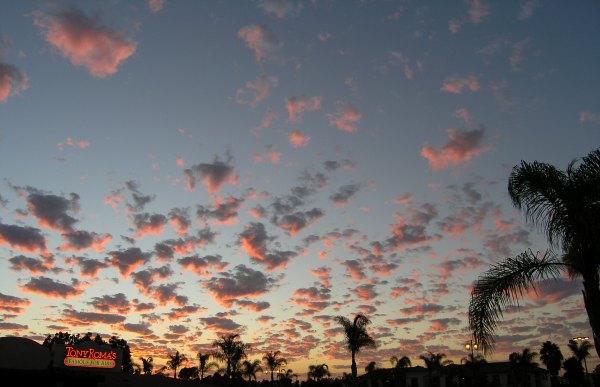
I took these next pictures from "S Mountain." I spent a lot of time looking for the cache, in light sprinkles of rain, but couldn't find it . . . So, another cache goes on my list of "As-Yet-Unfound Caches" bookmark list. Now I will get the logs by all the other people who make this "easy find."


It was time, finally, to start down the last stretch of road towards Lakewood. Along the way, I took a short detour to get to the "Midland Mystery Kid's Cache." I had an interesting experience with that cache, and it really turned into a mystery for me. The view from that vantage point is astounding on a clear day, but the clouds obscured it that afternoon. I took a picture of Toby's Gang's coin T.B. that had been stranded for months in a cache and which I had been "dipping" in caches along the way.


After finally finding that cache, I needed to hit the road and head down the backstretch to my destination. Before I got there, however, I stopped to look for one of the caches I DNFd last spring . . . it is still on my "As-Yet-Unfound Caches" bookmark list.


Thursday, September 07, 2006

Gallup, NM to Salida, CO and on towards the home stretch

After a long night spent in the filthy motel room hearing the trains, even with my ear plugs in place, as they traveled through town, my day started the way the previous day ended . . . with a DNF.

However, if the cache had not been placed near this beautiful mural, I would not have known it was there, and when I get back home and have time, I hope to set it up as a Waymark to draw others to see it.


At the restaurant where I got a cup of coffee that morning, a Tribal Policeman recommended I take the minor highway through the Indian Reservation up to Farmington. He said the main highway, which used to be US 666, has a lot more truck traffic, and "a lot of crazy drivers." On my way to the highway, I passed by Red Rock State park just east of Gallup, and saw some fantastic sandstone bluffs that reminded me of Kanab Canyon north of Kanab, Utah, where I used to take people for horseback rides.


Along this lonely road that rolled out in front of me for miles and miles, with no caches to pause for along the way, I stopped several times to take pictures of scenes that just "looked like New Mexico."


As the road climbed, it passed over the Continental Divide. Here in New Mexico, that divide happens at a much lower elevation than the same Continental Divide in Colorado.


After I took this picture, I went into the supermarket on the Reservation. I picked up some fresh fruit and while in the Produce Department, I heard the sound of rolling thunder. Soon afterwards, the system that mists the produce came on. I thought that was so much better than the little "ding" that warns me the mist is about to come on in my local store.

In Farmington, I stopped at a cache in a cacher's front yard. We shared Geocaching stories, and I let him "Discover" the coins I had with me, as well as the GJTB I had. He told me about a coffee shop in downtown Farmington where I could get a WiFi signal, so I backtracked to "Andrea Kristina's." The coffee was good, and strong, and since I had a rough night, I needed the caffeine to wake me up for the next stretch of the road.

As I downloaded a couple of PQs and loaded the GPSr with new maps and caches for the next section of my trip, I glanced around at the local people enjoying their coffee and delicious-looking sandwiches, and wished I could join in their conversations. It would have been interesting to learn what these sophisticated-looking people do in Farmington, and how they came to live there . . .

After a quick visit to the nicely-appointed restroom,


I was on my way, heading out of town on the highway towards Chama.

Along the way, I saw trucks sporting highly-visible orange flags on tall, flexible poles, and many gas wells. These eyesores were painted green to lessen their visual impact, but the scenery along the way would have looked much better without the wells, storage tanks, and roads that scared the area.

Higher up in the mountains, the scenery was beautiful, but I didn't take many pictures because of the overcast sky.


In Colorado, the small towns I encountered offered reasons to stop and take pictures.


After stopping to take a few pictures, and to find the "Howsan Park" cache, the one that turned out to be number 2000 for me, I got back on the highway so I could make it to Salida for the night. I liked that small city so much on my last trip, I wanted to stay there and spend more time exploring it on this adventure.

Late in the day, as I made that long drive up lonely Colorado Highway 17, past the turnoff for Great Sand Dunes National Monument where I spent a night last spring, I stopped to take a picture, in the rain, of my Waymark, a WiFi hotspot, The Mirage Trading Post.


And, finally, after turning onto Highway 50 from Highway 17, I stopped to get a picture of another one of my Waymarks, the "Highway 50 Pet Cemetary," before continuing to my "camping site" for the night . . . in the Wal-Mart parking lot . . .


Wednesday, September 06, 2006

From a nice campsite to a cheap motel on the second day

Since the moon was nearly full, it was light in my tent all night long, so when I woke up again in the night, I wasn't sure dawn was coming until I looked at the little clock next to my head. Before the sun came up, I got out of my sleeping bag, got dressed, and as the water for my coffee was heating on my little store, I walked around and took some pictures in the early morning light.


I love the shape of these huge Datura flowers.


After packing up the sleeping bag and tent, and putting everything in its place in the car, I talked to the other camper in the campground, an 84-year-old man. I admired his ability to set out at his age and experience the adventure of the road. He said he wanted to do this while he still could, but since his mother lived to be 113 years old, I think he'll be able to travel and camp for a lot longer than most 84-year-old men.

The next town on my big paper AAA map was Globe, and when I got into what looked like the outskirts of town, I pulled over and looked at the map on my GPSr. I didn't see any caches. I thought I loaded them for this section of the highway, but apparently I didn't. So, I opened the laptop, did a quick search for caches in this area, and then hand-entered the coordinates in my GPSr.

The first cache I went after was a Virtual, and the object I was looking for was a train. So, following the arrow on my GPSr, I went up one steep street, then down a narrow one-way street, then I drove up another steep street and back down a different one-way street. It was obvious I couldn't get to the train from that tangle of streets, so I tried another approach up a other narrow streets with small, crowded-together houses that had been built many decades ago.

Someone else would have figured it out sooner than I did — that a train wouldn't be up on that steep hillside — but it took me a while. When I brought up the cache page again, sure enough, I saw I had entered the coordinates incorrectly. Doh!

I was actually glad I made that mistake because I never would have ventured up into that area otherwise and it showed me how other people have to live their lives because of oppressive poverty.

Finally back on the main road, I followed the arrow on my GPSr to my first cache of the day, a micro at a Church's Chicken. There was a great view from the cache location at the top of the steep hill at the edge of town.

In downtown Globe, there were wonderful old buildings built during the mining days in the 1800's and early 1900's. Many of them house antique shops today. It was too early for any of them to be open, so I continued to the Virtual at the train and another Virtual called "God's Alarm Clock."


Highway 60 makes a hard left turn as you drive north out of town and heads up through the Fort Apache Indian Reservation. For miles, the highway rolls along and along, and on my GPSr, there was not a cache in sight. The highway climbs up gradually, and then, when it reaches the Salt River Canyon, a sequence of hairpin turns takes you down, down, down near the bottom of the sandstone-walled canyon.

At the wonderful old bridge, built during the art deco era of the 30s, there was a cache to search for, but first I inspected the beautiful jewelry and crafts offered by the Native American vendors there.

I walked down next to the river, and searched for the cache down there, around the supporting beams of the bridge above. Finally, after giving up the search there, I walked out onto the old bridge and searched there. I had no luck there, but did find two Arizona Highway Department benchmarks which I photographed and marked, in case I want to log them as Waymarks when I return.

At last I got back on the highway, eventually making my way to Show Low, a wonderful town nestled in a pine forest. I found a TB hotel where I took this picture of all of them getting together to share their various experiences.


After going to the library in town to once again log the Trackables I had picked up and dropped off, I went to the Virtual cache at this great sculptures.


There was another long stretch of highway before I arrived in New Mexico. Right at the border, sandstone bluffs occur, and a traveler knows they are in a different State. Right at that border, it looks like New Mexico is supposed to look.


I had a great time in Gallup, looking for several caches placed by one person who highlighted interesting things in town, including the old REX hotel, and the famous El Rancho Motel.

If the sky had not looked so threatening, I would have driven east of town to the State Campground. I really wanted to take a shower, so I found a very inexpensive motel on the east side of town.

When I pulled in, I parked next to a car exactly like mine — same color, same basic model. The owner of that car was just returning from inspecting one of the rooms. He returned the key to the motel owner, and drove away, just as I signed in and got the key for my room.

I'm not proud, the price was right, and I really, really wanted to take a hot shower.


Tuesday, September 05, 2006

Beginning of my road trip to "Cache Across America -- AZ"

After my road trip to Lakewood, Colorado last spring, which I took to assist my sister in her effort to organize my 90-year old mother's apartment, I did not think I would ever take another road trip. This in spite of the fact that I feel more alive, more like me, when I am out adventuring like that.

However, a wonderful opportunity, to attend my cousin's 50th Wedding Anniversary Celebration on September 9th, presented itself, so I made preparations for the drive.

Since I am nearly incapable of planning, I didn't know which roads or highways I was going to take, so I didn't use the new "Caches Along a Route" feature on GC.com. I just requested several PQs from Yuma through Phoenix to Globe and Show Low and on up to Gallup and Farmington. From there, I included both the Durango area and the Salida area, and even Grand Junction. By the time I got all the data in my Arizona, New Mexico, Utah, Colorado, and Nevada databases in GSAK, I had more than 6,000 caches to search for . . . and those were only the ones with a difficulty and terrain rating of 2.5 and below.

The morning I left, it was beautiful. The vista that opens up above the Buckman Springs exit off I-8 looked like a Thomas Moran painting. Old Highway 80, which parallels the Interstate there, beckoned me, but I was too close to home, and too far from my destination to slow down now. However, at the exit for the Golden Acorn Casino, I stopped. On Tuesdays, they give away money — six dollars, to be exact. So, I went in, got my six dollars, and left, only a little bit tempted to put the money in one of the slot machines. After I got in the car, I took the old road to find a new cache I became aware of because of some controversy about it in our local Forums.

In the ammo can, I found not only a Green Jeep, to accompany the other GJTB I was taking on the road trip, but a "Geo-nut" Geocoin. Since the goal of Trackables is to travel, I took both of them with me, with some guilt about doing that since the cache wouldn't have anything in it to draw people to it now.

In El Centro, I got off the freeway to find the library. Logging the GJTB and the coin was important. I didn't want anyone heading out to that remote cache for those prizes and finding them missing . . . and wondering what happened to them. At the library, I logged the retrieval, on an ancient Gateway computer even slower than my own computer. I didn't log my find . . . I would take the time to do that later. When I got back in the car, I followed the arrow on my GPSr to a "Homer" cache before finally hitting the Interstate again.

I took a couple of quick pictures of the scenery, out the window traveling 70 mph on Interstate 8, . . . not a recommended practice. [g]


In Yuma, it was hot . . . but it is a dry heat. [g] I took the time to drive around and find a few caches there. I picked up some more Travel Bugs to join the large group of TBs already in my possession. My "caching fix" satisfied, I got back on the Interstate heading for the "Cache Across America — Arizona." On my last trip, I found the caches along this long stretch of highway. No new ones had been placed, so there was nothing to stop for. The miles rolled on, with the desert scenery as my road trip movie for the time it took me to get to Dateland, where I stopped and got a picture of one of the TBs at the memorial there.


A cup of coffee fortified me for the drive to my "Cache Across America — Arizona" destination. This series of caches got its start when Blue Power Ranger posted a thread in the Groundspeak Forums. I followed the thread for several weeks as volunteers all around the country offered to place the cache for their State. If only I could find someone to finance my journey, I would continue right now to find the rest of the caches in the series.

As I made my way up the rocky hill towards GZ, walking very carefully around the Cholla cactus and other spiny vegetation, such as the infamous "Wait A Minute, Catclaw" bush, I was dripping sweat.

I found myself on the wrong side of a fence — twice — but finally spotted a large rockpile that "cammoflaged" the large ammo can hidden at the base of Picacho Peak. The sun was low in the sky, and not conducive to a good photograph of that well-known Arizona landmark, so I didn't take any pictures of it. I did take the obligatory photograph for the cache series. Who knows, maybe something will happen someday, somehow, to enable me to complete the series


To get to the "Cache Across America — Arizona" cache, I had gone a bit out of my way, so I backtracked to find the little connecting Highway 87, which would get me to the interesting desert town of Florence, a town which had a much richer, more vibrant past than it has today.

The museum in town was closed, so I was unable to fulfill the obligations required by the cache owner for the Virtual cache there, but that old courthouse was interesting, and I think I got enough information to list it as National Register of Historic Places Waymark. As I navigated back to the highway, I saw this beautiful building before heading out of town and up Highway 79 to Highway 60, which would get to to a higher, cooler elevation where camping would be much more comfortable.


On the road trip last spring, at the end of the each day, I did not know where I was going to spend the night. That was true for this day as well. As the sun went down, and dusk was turning to dark, I felt the fatigue of the road and needed to find a place to stop. Up, up up the highway climbed, and then, I saw a sign for the Oak Flat Campground. The exit to this small, relatively-primitive campground is near N°33 18.770 W° 111 02.974.

I turned off the highway, negotiated past large potholes in the road, and found the nearly-deserted campground with all the amenities I would need for the night — a nearby outhouse.


Sunday, September 03, 2006

A new record of finds in one day -- 47 with only 2 DNF's

When I learned the San Diego Cache Event Team was headed north to beat the heat Saturday, I wasn't even thinking about how many caches I might find during the day. I just wanted to get out and see my Geocaching friends again. At the last minute, I found out jahoadi and john were going and they let me ride up with them after meeting them down the hill near their house.

We started out near Oceanside Harbor and ultimately walked out to the end of the jetty again. My photos aren't as good as the one Duncan! got and which I used here last year, but I tried.


This little crab was waiting for the tide to come back in so it could enjoy mealtime again.


Although it was a beautiful day, I didn't take too many pictures. That was until just after sunset, when these wonderful little clouds were illuminated by the sun below the horizon.


It was a really fun day, marred only by the hard fall I took while trying to get to the beach on a steep little trail down the cliffs. Jahoadi overcame her fear of blood to put bandaids over the "road rash" I got when I fell on a large rock I expected to be part of the sandy cliff. Even the neoprene cover on my GPSr was damaged when it hit the rock.

At the time I fell, I was being very careful and cautious. It happened so fast, I hit the ground before I even knew my feet were slipping . . .

Something like that sure makes you think about what can happen . . . and since I am heading out on a road trip by myself in a couple of days, I'll have to be even more cautious when heading out on the trails solo.


Web Counters
Office Max Coupon